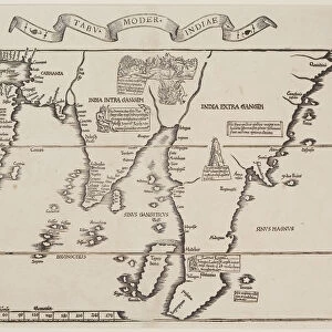
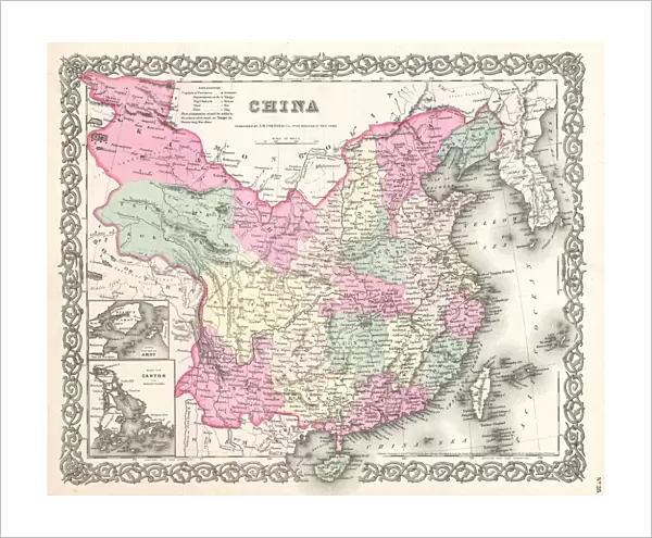
Fine Art Print : 1855, Colton Map of China, Taiwan, and Korea, topography, cartography, geography


![]()
Fine Art Prints from Liszt Collection
1855, Colton Map of China, Taiwan, and Korea, topography, cartography, geography
1855, Colton Map of China, Taiwan, and Korea
Liszt Collection of nineteenth-century engravings and images to browse and enjoy
Media ID 14005469
© Artokoloro Quint Lox Limited
1855 Taiwan Antique Map Latitude Longitude Mappa Mundi Old Antique Plan Old Antique View Ols Antique Map Rare Old Maps Topo
20"x16" (+3" Border) Fine Art Print
Discover the rich history and intricate detail of the past with our exquisite Fine Art Print from the Media Storehouse collection. This stunning representation is taken from the 1855 Colton Map of China, Taiwan, and Korea, hailing from the esteemed Liszt Collection. Delve into the topography, cartography, and geography of the region as depicted in this masterpiece of 19th-century cartography. Bring the captivating history of East Asia into your home or office, and add a touch of sophistication and depth to your decor with this beautiful and educational piece.
20x16 image printed on 26x22 Fine Art Rag Paper with 3" (76mm) white border. Our Fine Art Prints are printed on 300gsm 100% acid free, PH neutral paper with archival properties. This printing method is used by museums and art collections to exhibit photographs and art reproductions.
Our fine art prints are high-quality prints made using a paper called Photo Rag. This 100% cotton rag fibre paper is known for its exceptional image sharpness, rich colors, and high level of detail, making it a popular choice for professional photographers and artists. Photo rag paper is our clear recommendation for a fine art paper print. If you can afford to spend more on a higher quality paper, then Photo Rag is our clear recommendation for a fine art paper print.
Estimated Image Size (if not cropped) is 49.9cm x 40.6cm (19.6" x 16")
Estimated Product Size is 66cm x 55.9cm (26" x 22")
These are individually made so all sizes are approximate
Artwork printed orientated as per the preview above, with landscape (horizontal) orientation to match the source image.
EDITORS COMMENTS
This print showcases the remarkable "1855, Colton Map of China, Taiwan, and Korea" a true masterpiece in topography, cartography, and geography. With its intricate details and precise illustrations, this vintage map takes us on a journey through time to explore the ancient lands of East Asia. The carefully crafted lines and grids depict latitude and longitude coordinates with geometric precision, offering an invaluable tool for navigation during that era. This historic artifact not only serves as a window into the past but also reveals the extensive knowledge of our ancestors in mapping out uncharted territories. As we gaze upon this aged piece of artistry, we are transported back to an era when exploration was at its peak. The delicate brushstrokes capture every contour of the land while showcasing various regions within China, Taiwan, and Korea. It is truly fascinating to witness how these countries were perceived over 150 years ago. This rare old map holds immense historical significance as it provides insights into early global understanding and interconnectivity. Its decorative elements add charm to any space where it is displayed - be it a study room or an antique collector's gallery. With each glance at this mesmerizing relic from another time, we are reminded of humanity's insatiable thirst for discovery and our continuous quest to understand our world better.
MADE IN THE USA
Safe Shipping with 30 Day Money Back Guarantee
FREE PERSONALISATION*
We are proud to offer a range of customisation features including Personalised Captions, Color Filters and Picture Zoom Tools
SECURE PAYMENTS
We happily accept a wide range of payment options so you can pay for the things you need in the way that is most convenient for you
* Options may vary by product and licensing agreement. Zoomed Pictures can be adjusted in the Cart.