Fine Art Print > Europe > France > Canton > Landes
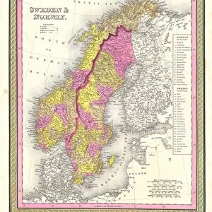
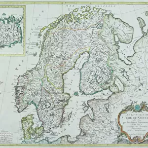
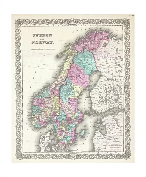
Fine Art Print : 1855, Colton Map of Scandinavia, Norway, Sweden, Finland, topography, cartography


![]()
Fine Art Prints from Liszt Collection
1855, Colton Map of Scandinavia, Norway, Sweden, Finland, topography, cartography
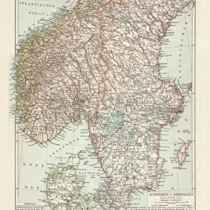
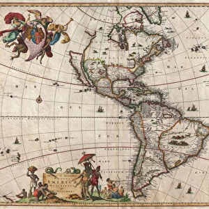
1855, Colton Map of Scandinavia, Norway, Sweden, Finland
Liszt Collection of nineteenth-century engravings and images to browse and enjoy
Media ID 14005495
© Artokoloro Quint Lox Limited
1855 Finland Norway Sweden Antique Map Latitude Longitude Mappa Mundi Old Antique Plan Old Antique View Ols Antique Map Rare Old Maps Topo
20"x16" (+3" Border) Fine Art Print
Discover the captivating history and geography of Scandinavia with our exquisite 1855 Colton Map of Norway, Sweden, and Finland from the esteemed Liszt Collection. This fine art print showcases intricate topographical and cartographical details, transporting you back in time to an era of exploration and discovery. Each print is meticulously crafted using high-quality materials and techniques, ensuring a stunning addition to your home or office decor. Bring a piece of historical cartography into your space and elevate your interior design with this beautiful and educational art piece.
20x16 image printed on 26x22 Fine Art Rag Paper with 3" (76mm) white border. Our Fine Art Prints are printed on 300gsm 100% acid free, PH neutral paper with archival properties. This printing method is used by museums and art collections to exhibit photographs and art reproductions.
Our fine art prints are high-quality prints made using a paper called Photo Rag. This 100% cotton rag fibre paper is known for its exceptional image sharpness, rich colors, and high level of detail, making it a popular choice for professional photographers and artists. Photo rag paper is our clear recommendation for a fine art paper print. If you can afford to spend more on a higher quality paper, then Photo Rag is our clear recommendation for a fine art paper print.
Estimated Image Size (if not cropped) is 40.6cm x 49cm (16" x 19.3")
Estimated Product Size is 55.9cm x 66cm (22" x 26")
These are individually made so all sizes are approximate
Artwork printed orientated as per the preview above, with portrait (vertical) orientation to match the source image.
FEATURES IN THESE COLLECTIONS
> Europe
> Finland
> Related Images
> Europe
> France
> Canton
> Landes
> Europe
> Norway
> Related Images
> Europe
> Sweden
> Related Images
EDITORS COMMENTS
This print showcases a remarkable piece of history - the 1855 Colton Map of Scandinavia, Norway, Sweden, and Finland. With its intricate topography and meticulous cartography, this map offers a fascinating glimpse into the geographical features and land formations of these Nordic countries during that era. The vintage charm of this ancient map is evident in its aged paper texture and retro artistic style. It serves as a testament to the artistry and skill involved in creating such detailed illustrations before the advent of modern technology. As you explore this historic treasure, you can't help but be transported back in time to an age when navigation relied on maps like these for exploration and discovery. The grid lines depicting latitude and longitude add a touch of geometric precision to the overall composition. This rare antique map not only provides valuable insights into Scandinavia's past but also serves as an intriguing decorative piece for any space. Its historical significance makes it a must-have for collectors or anyone with an appreciation for world history. Whether displayed in your home or office, this stunning print from Liszt Collection invites you to embark on a journey through time while admiring the beauty of our planet's diverse regions.
MADE IN THE USA
Safe Shipping with 30 Day Money Back Guarantee
FREE PERSONALISATION*
We are proud to offer a range of customisation features including Personalised Captions, Color Filters and Picture Zoom Tools
SECURE PAYMENTS
We happily accept a wide range of payment options so you can pay for the things you need in the way that is most convenient for you
* Options may vary by product and licensing agreement. Zoomed Pictures can be adjusted in the Cart.