Fine Art Print > Oceania > Australia > Related Images
Fine Art Print : Australia and Oceania Map, atlas by Th. von Liechtenstern and Henry Lange, antique


![]()
Fine Art Prints from Liszt Collection
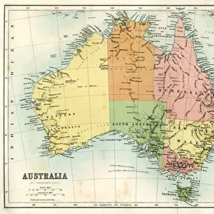
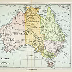
Australia and Oceania Map, atlas by Th. von Liechtenstern and Henry Lange, antique
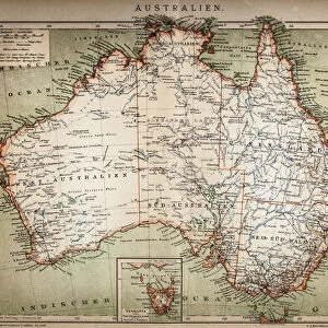
Australia and Oceania Map, atlas by Th. von Liechtenstern and Henry Lange, antique map 1869
Liszt Collection of nineteenth-century engravings and images to browse and enjoy
Media ID 12665813
© Quint Lox Limited
1869 Australia Henry Lange Th Von Liechtenstern Antique Map
20"x16" (+3" Border) Fine Art Print
Step back in time with our exquisite Fine Art Print of the Australia and Oceania Map from the renowned atlas by Th. von Liechtenstern and Henry Lange, dating back to 1869. This antique map, part of the esteemed Liszt Collection, showcases intricate detail and beautiful cartography of the Australia and Oceania region during the late 19th century. Add an air of history and sophistication to your home or office with this stunning piece of cartographic art.
20x16 image printed on 26x22 Fine Art Rag Paper with 3" (76mm) white border. Our Fine Art Prints are printed on 300gsm 100% acid free, PH neutral paper with archival properties. This printing method is used by museums and art collections to exhibit photographs and art reproductions.
Our fine art prints are high-quality prints made using a paper called Photo Rag. This 100% cotton rag fibre paper is known for its exceptional image sharpness, rich colors, and high level of detail, making it a popular choice for professional photographers and artists. Photo rag paper is our clear recommendation for a fine art paper print. If you can afford to spend more on a higher quality paper, then Photo Rag is our clear recommendation for a fine art paper print.
Estimated Image Size (if not cropped) is 46.4cm x 40.6cm (18.3" x 16")
Estimated Product Size is 66cm x 55.9cm (26" x 22")
These are individually made so all sizes are approximate
Artwork printed orientated as per the preview above, with landscape (horizontal) orientation to match the source image.
FEATURES IN THESE COLLECTIONS
> Oceania
> Australia
> Related Images
EDITORS COMMENTS
This print showcases an exquisite antique map of Australia and Oceania, meticulously crafted by the renowned cartographers Th. von Liechtenstern and Henry Lange in 1869. The map, a true testament to their expertise, offers a fascinating glimpse into the geographical landscape of this vast region during that era. As we delve into this vintage masterpiece, we are transported back in time to an age when exploration was at its peak. Every intricate detail on the map tells a story of intrepid adventurers who braved uncharted waters and unknown territories to unravel the mysteries of Australia and Oceania. The delicate lines etched onto aged parchment depict not only the coastlines but also highlight major cities, rivers, mountain ranges, and islands scattered across these lands. It is as if we can almost hear whispers from history itself as we trace our fingers along each contour. This remarkable piece evokes a sense of nostalgia for times long gone yet still holds relevance today. It serves as a reminder of how far our understanding has come since then while honoring those who dedicated their lives to mapping out these distant realms. Whether you are an avid collector or simply captivated by history's allure, this antique map from Liszt Collection will undoubtedly be cherished for generations to come. Its timeless beauty invites us to explore the past while igniting curiosity about what lies beyond those faded borders on its surface.
MADE IN THE USA
Safe Shipping with 30 Day Money Back Guarantee
FREE PERSONALISATION*
We are proud to offer a range of customisation features including Personalised Captions, Color Filters and Picture Zoom Tools
SECURE PAYMENTS
We happily accept a wide range of payment options so you can pay for the things you need in the way that is most convenient for you
* Options may vary by product and licensing agreement. Zoomed Pictures can be adjusted in the Cart.