Fine Art Print > Liszt Collection > Engravings
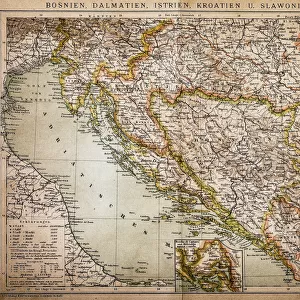
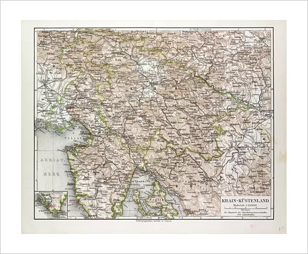
Fine Art Print : Map of Slovenia and Croatia, 1899


![]()
Fine Art Prints from Liszt Collection
Map of Slovenia and Croatia, 1899
Liszt Collection of nineteenth-century engravings and images to browse and enjoy
Media ID 12974343
© Quint Lox Limited
1899 Croatia Plan Slovenia Chart
20"x16" (+3" Border) Fine Art Print
Discover the rich history and cultural connections between Slovenia and Croatia with our exquisite Fine Art Print of the Map of Slovenia and Croatia, 1899 from the esteemed Liszt Collection. This stunning vintage map, dating back to 1899, showcases intricate details of the regions' borders, topography, and cities. A beautiful addition to any home or office, this Fine Art Print is not only a decorative piece but also a glimpse into the past. Bring a piece of history into your space and elevate your interior design with this captivating and timeless print.
20x16 image printed on 26x22 Fine Art Rag Paper with 3" (76mm) white border. Our Fine Art Prints are printed on 300gsm 100% acid free, PH neutral paper with archival properties. This printing method is used by museums and art collections to exhibit photographs and art reproductions.
Our fine art prints are high-quality prints made using a paper called Photo Rag. This 100% cotton rag fibre paper is known for its exceptional image sharpness, rich colors, and high level of detail, making it a popular choice for professional photographers and artists. Photo rag paper is our clear recommendation for a fine art paper print. If you can afford to spend more on a higher quality paper, then Photo Rag is our clear recommendation for a fine art paper print.
Estimated Image Size (if not cropped) is 50.3cm x 40.6cm (19.8" x 16")
Estimated Product Size is 66cm x 55.9cm (26" x 22")
These are individually made so all sizes are approximate
Artwork printed orientated as per the preview above, with landscape (horizontal) orientation to match the source image.
EDITORS COMMENTS
This print showcases a remarkable piece of history - the "Map of Slovenia and Croatia, 1899". A true treasure from the nineteenth century, this engraved image offers a glimpse into the past with its intricate illustrative technique. The Victorian era comes to life through the artful engravement, showcasing an impressive display of arts and culture. The retro-styled vintage aesthetic adds an extra layer of charm to this map, making it a perfect addition to any collection or decor. With its detailed depiction of Slovenia and Croatia, this map serves as both a plan and chart for those interested in exploring these beautiful regions. The Arkheia's meticulous preservation has allowed us to enjoy this historical gem today. As we admire the craftsmanship that went into creating such a masterpiece over a century ago, we can't help but marvel at how far cartography has come since then. Whether you're an avid history enthusiast or simply appreciate fine art, this print is sure to captivate your imagination. It invites you on a journey back in time while simultaneously adding character and sophistication to any space it graces.
MADE IN THE USA
Safe Shipping with 30 Day Money Back Guarantee
FREE PERSONALISATION*
We are proud to offer a range of customisation features including Personalised Captions, Color Filters and Picture Zoom Tools
SECURE PAYMENTS
We happily accept a wide range of payment options so you can pay for the things you need in the way that is most convenient for you
* Options may vary by product and licensing agreement. Zoomed Pictures can be adjusted in the Cart.