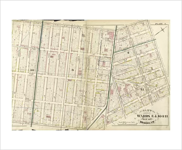
Fine Art Print : Plate 4: Part of Wards 3, 4, 10, & 11. City of Brooklyn


![]()
Fine Art Prints from Liszt Collection
Plate 4: Part of Wards 3, 4, 10, & 11. City of Brooklyn
Liszt Collection of nineteenth-century engravings and images to browse and enjoy
Media ID 12671633
© Quint Lox Limited
Cartographic Historic Map Plate 4 Vintage Map
20"x16" (+3" Border) Fine Art Print
Experience the rich history and vibrant character of Brooklyn's past with our exquisite Fine Art Print from the Liszt Collection. This stunning representation, Plate 4: Part of Wards 3, 4, 10, & 11. City of Brooklyn, transports you back in time with intricate details and authenticity. Each print is meticulously crafted using high-quality materials and techniques, ensuring a beautiful and long-lasting addition to your home or office decor. Bring a piece of Brooklyn's heritage into your space and elevate your interior design with this captivating work of art.
20x16 image printed on 26x22 Fine Art Rag Paper with 3" (76mm) white border. Our Fine Art Prints are printed on 300gsm 100% acid free, PH neutral paper with archival properties. This printing method is used by museums and art collections to exhibit photographs and art reproductions.
Our fine art prints are high-quality prints made using a paper called Photo Rag. This 100% cotton rag fibre paper is known for its exceptional image sharpness, rich colors, and high level of detail, making it a popular choice for professional photographers and artists. Photo rag paper is our clear recommendation for a fine art paper print. If you can afford to spend more on a higher quality paper, then Photo Rag is our clear recommendation for a fine art paper print.
Estimated Image Size (if not cropped) is 50.8cm x 35.5cm (20" x 14")
Estimated Product Size is 66cm x 55.9cm (26" x 22")
These are individually made so all sizes are approximate
Artwork printed orientated as per the preview above, with landscape (horizontal) orientation to match the source image.
EDITORS COMMENTS
This vintage map, titled "Plate 4: Part of Wards 3,4,10 & 11. City of Brooklyn" is a captivating piece from the Liszt Collection. The intricate cartography and historic charm of this print transport us back to the early days of Brooklyn, New York. With its detailed representation of wards and city boundaries, this map offers a fascinating glimpse into the geography and layout of old Brooklyn. It showcases the development and expansion that took place in these specific areas during that time. The muted colors and delicate lines evoke a sense of nostalgia, reminding us of an era when maps were meticulously hand-drawn works of art. This particular print captures not only the essence but also the history behind America's urban landscapes. As we study this map closely, we can imagine how life might have been in those neighborhoods over a century ago – bustling streets filled with horse-drawn carriages, charming brownstone houses lining quiet avenues. Whether you are a history enthusiast or simply appreciate beautiful cartographic pieces, this vintage map will undoubtedly make for an intriguing addition to your collection. Its timeless appeal serves as both an educational tool and a decorative element for any space
MADE IN THE USA
Safe Shipping with 30 Day Money Back Guarantee
FREE PERSONALISATION*
We are proud to offer a range of customisation features including Personalised Captions, Color Filters and Picture Zoom Tools
SECURE PAYMENTS
We happily accept a wide range of payment options so you can pay for the things you need in the way that is most convenient for you
* Options may vary by product and licensing agreement. Zoomed Pictures can be adjusted in the Cart.