Fine Art Print > Europe > United Kingdom > England > Birmingham > Area > Highgate
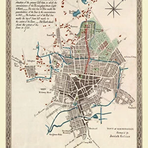
Fine Art Print : Old Map of Birmingham 1851 by John Tallis


![]()
Fine Art Prints from MapSeeker
Old Map of Birmingham 1851 by John Tallis
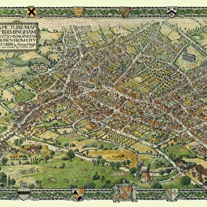
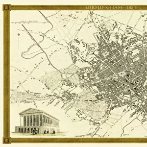
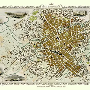
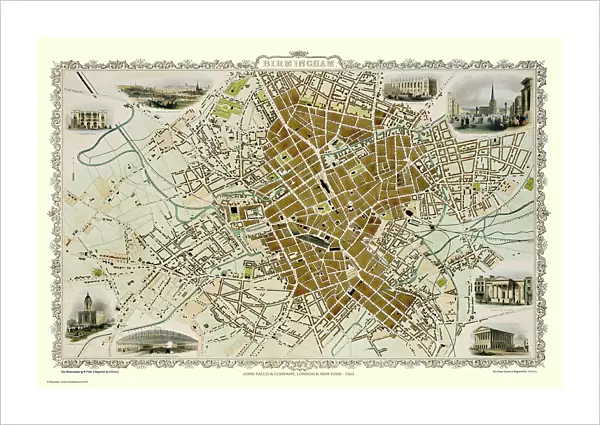
This attractive plan of mid Victorian Birmingham in the Midlands by John Tallis 1851 shows the first railways and important canal network. The work is attractively presented with eight illustrations. These are the Theatre Royal, King Edward School, School of Design, Town Hall, the London and North Western Railway Station and St Phillips Church. At the top left there is a view across Birmingham from Highgate. Finishing the work there is a busy scene from Birminghams famous Bull Ring
Welcome to the Mapseeker Image library and enter an historic gateway to one of the largest on-line collections of Historic Maps, Nostalgic Views, Vista's and Panorama's from a World gone by.
Media ID 20347868
Birmingham Birmingham City Birmingham City Map Birmingham Map Birmingham Town Plan Historic Birmingham Map Historic Map John Tallis John Tallis Map Map Of Birmingham Old Map Of Birmingham Old Town Plan Tallis Map Town Plan Of Birmingham
21"x14" (+3" Border) Fine Art Print
Step back in time with our exquisite Old Map of Birmingham 1851 by John Tallis from our Media Storehouse Fine Art Prints collection. This captivating mid-Victorian representation of Birmingham in the Midlands showcases the city's burgeoning railway system and intricate canal network. With eight beautifully detailed illustrations, this fine art print is an essential addition to any home or office space, transporting you back to an era of industrial innovation and growth. Bring history to life with this stunning piece of cartographic artistry.
21x14 image printed on 27x20 Fine Art Rag Paper with 3" (76mm) white border. Our Fine Art Prints are printed on 300gsm 100% acid free, PH neutral paper with archival properties. This printing method is used by museums and art collections to exhibit photographs and art reproductions.
Our fine art prints are high-quality prints made using a paper called Photo Rag. This 100% cotton rag fibre paper is known for its exceptional image sharpness, rich colors, and high level of detail, making it a popular choice for professional photographers and artists. Photo rag paper is our clear recommendation for a fine art paper print. If you can afford to spend more on a higher quality paper, then Photo Rag is our clear recommendation for a fine art paper print.
Estimated Image Size (if not cropped) is 53.3cm x 35.5cm (21" x 14")
Estimated Product Size is 68.6cm x 50.8cm (27" x 20")
These are individually made so all sizes are approximate
Artwork printed orientated as per the preview above, with landscape (horizontal) orientation to match the source image.
FEATURES IN THESE COLLECTIONS
> Arts
> Artists
> P
> John Phillip
> Arts
> Artists
> T
> John Tallis
> Europe
> United Kingdom
> England
> Birmingham
> Area
> Highgate
> Europe
> United Kingdom
> England
> London
> Art
> Theatre
> Europe
> United Kingdom
> England
> London
> Royalty
> Europe
> United Kingdom
> England
> London
> Towns
> Highgate
> Europe
> United Kingdom
> England
> London
> Transport
> Railway
> Europe
> United Kingdom
> England
> London
> Transport
> Stations
> Maps and Charts
> Related Images
> Popular Themes
> Railway Posters
> MapSeeker
> British Town And City Plans
> English & Welsh PORTFOLIO
EDITORS COMMENTS
This print showcases an exquisite piece of history - the Old Map of Birmingham from 1851 by John Tallis. This meticulously detailed plan offers a glimpse into mid-Victorian Birmingham, highlighting its first railways and significant canal network. The map is not only informative but also aesthetically pleasing, featuring eight beautifully illustrated landmarks that define the city's identity. Amongst these illustrations are iconic structures such as the Theatre Royal, King Edward School, School of Design, Town Hall, London and North Western Railway Station, and St Phillips Church. Each illustration brings to life a different aspect of Birmingham's rich cultural heritage. At the top left corner of this remarkable work lies a breathtaking view across Birmingham from Highgate. This vantage point allows us to appreciate the cityscape as it was over 150 years ago – a testament to how much has changed yet remained intact. To conclude this magnificent composition is a bustling scene from Birmingham's renowned Bull Ring. This depiction captures the vibrant energy that has always characterized this historic marketplace. The Old Map of Birmingham by John Tallis serves as both an educational resource for historians and geography enthusiasts alike and a stunning piece of art that can adorn any wall with its timeless charm. It invites viewers to delve into the past while marveling at the beauty and intricacy captured within its borders.
MADE IN THE USA
Safe Shipping with 30 Day Money Back Guarantee
FREE PERSONALISATION*
We are proud to offer a range of customisation features including Personalised Captions, Color Filters and Picture Zoom Tools
SECURE PAYMENTS
We happily accept a wide range of payment options so you can pay for the things you need in the way that is most convenient for you
* Options may vary by product and licensing agreement. Zoomed Pictures can be adjusted in the Cart.