Fine Art Print > Maps and Charts > Related Images
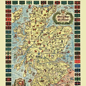
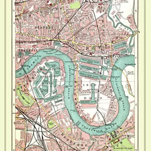
Fine Art Print : Old Map of Rushall to Daw End near Walsall 1888


![]()
Fine Art Prints from MapSeeker
Old Map of Rushall to Daw End near Walsall 1888
PL011
Welcome to the Mapseeker Image library and enter an historic gateway to one of the largest on-line collections of Historic Maps, Nostalgic Views, Vista's and Panorama's from a World gone by.
Media ID 20348241
20"x16" (+3" Border) Fine Art Print
Discover the rich history of Walsall with our exquisite Old Map of Rushall to Daw End print from Media Storehouse. Dating back to 1888, this fine art print, featuring the Old MapSeeker design (PL011), showcases intricate details of the area's historical landscape. Bring a piece of the past into your home or office and add an elegant touch to your decor. This high-quality print is a must-have for history enthusiasts and local residents alike.
20x16 image printed on 26x22 Fine Art Rag Paper with 3" (76mm) white border. Our Fine Art Prints are printed on 300gsm 100% acid free, PH neutral paper with archival properties. This printing method is used by museums and art collections to exhibit photographs and art reproductions.
Our fine art prints are high-quality prints made using a paper called Photo Rag. This 100% cotton rag fibre paper is known for its exceptional image sharpness, rich colors, and high level of detail, making it a popular choice for professional photographers and artists. Photo rag paper is our clear recommendation for a fine art paper print. If you can afford to spend more on a higher quality paper, then Photo Rag is our clear recommendation for a fine art paper print.
Estimated Image Size (if not cropped) is 40.6cm x 50.8cm (16" x 20")
Estimated Product Size is 55.9cm x 66cm (22" x 26")
These are individually made so all sizes are approximate
Artwork printed orientated as per the preview above, with portrait (vertical) orientation to match the source image.
FEATURES IN THESE COLLECTIONS
> Maps and Charts
> Related Images
> MapSeeker
> British Town And City Plans
> English & Welsh PORTFOLIO
EDITORS COMMENTS
This print showcases an exquisite piece of history, the "Old Map of Rushall to Daw End near Walsall 1888 (PL011)". Transporting us back in time, this historic map offers a fascinating glimpse into the past. With intricate details and delicate craftsmanship, it serves as a testament to the artistry and precision of cartography in the late 19th century. The map specifically focuses on Rushall village, nestled near Walsall in England. Its carefully drawn lines trace the streets and landmarks that once defined this quaint community. Every corner is meticulously labeled, allowing us to envision how life unfolded within these boundaries over a century ago. As we explore this vintage treasure, our imagination runs wild with stories from bygone eras. We can almost hear the bustling sounds of horse-drawn carriages echoing through its narrow lanes or picture villagers going about their daily routines amidst charming cottages and local shops. While admiring this remarkable piece of history, let's appreciate its significance beyond commercial use. Let's cherish it for what it truly represents: a tangible connection to our heritage and an opportunity to reflect upon how far we have come since those days gone by. Whether you are a history enthusiast or simply captivated by antiquity, this old map of Rushall Village will undoubtedly transport you back in time – inviting you to walk alongside generations long past while marveling at their world preserved on paper.
MADE IN THE USA
Safe Shipping with 30 Day Money Back Guarantee
FREE PERSONALISATION*
We are proud to offer a range of customisation features including Personalised Captions, Color Filters and Picture Zoom Tools
SECURE PAYMENTS
We happily accept a wide range of payment options so you can pay for the things you need in the way that is most convenient for you
* Options may vary by product and licensing agreement. Zoomed Pictures can be adjusted in the Cart.