Fine Art Print > Arts > Artists > T > John Tallis
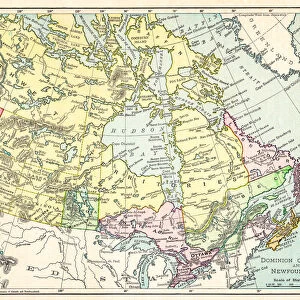
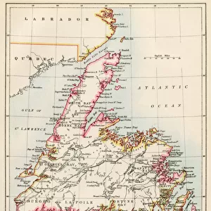
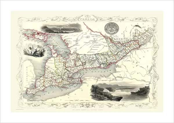
Fine Art Print : Old Map of West Canada 1851 by John Tallis


![]()
Fine Art Prints from MapSeeker
Old Map of West Canada 1851 by John Tallis
A fine facimile artworked from an antique original map of West Canada, issued as part of the 1851 edition of John Tallis and Companys " The Illustrated Atlas and Modern History of the World"
Welcome to the Mapseeker Image library and enter an historic gateway to one of the largest on-line collections of Historic Maps, Nostalgic Views, Vista's and Panorama's from a World gone by.
Media ID 20347656
© Mapseeker Publishing Ltd
John Tallis John Tallis Map Tallis Tallis Map West Canada Western Canada
21"x14" (+3" Border) Fine Art Print
Discover the rich history of Canada with our exquisite Old Map of West Canada 1851 by John Tallis and John Rapkin from our Media Storehouse Fine Art Prints collection. This stunning facsimile is meticulously crafted from an original antique map, taken from the 1851 edition of John Tallis and Company's "The Illustrated Atlas". Bring the intricate details and captivating history of this rare map into your home or office, and add a touch of timeless elegance to your decor. Our Fine Art Prints are carefully produced using high-quality materials, ensuring a beautiful and long-lasting addition to your space. Order yours today and step back in time with this extraordinary piece of cartographic history.
21x14 image printed on 27x20 Fine Art Rag Paper with 3" (76mm) white border. Our Fine Art Prints are printed on 300gsm 100% acid free, PH neutral paper with archival properties. This printing method is used by museums and art collections to exhibit photographs and art reproductions.
Our fine art prints are high-quality prints made using a paper called Photo Rag. This 100% cotton rag fibre paper is known for its exceptional image sharpness, rich colors, and high level of detail, making it a popular choice for professional photographers and artists. Photo rag paper is our clear recommendation for a fine art paper print. If you can afford to spend more on a higher quality paper, then Photo Rag is our clear recommendation for a fine art paper print.
Estimated Image Size (if not cropped) is 53.3cm x 35.5cm (21" x 14")
Estimated Product Size is 68.6cm x 50.8cm (27" x 20")
These are individually made so all sizes are approximate
Artwork printed orientated as per the preview above, with landscape (horizontal) orientation to match the source image.
FEATURES IN THESE COLLECTIONS
> Arts
> Artists
> T
> John Tallis
> Maps and Charts
> Related Images
> Maps and Charts
> World
> North America
> Canada
> Maps
> North America
> Canada
> Related Images
> MapSeeker
> Maps of the Americas
> Maps of Canada, Newfoundland
Old Map of West Canada 1851 - A Glimpse into the Rich History of Western Canada
EDITORS COMMENTS
. This print showcases an exquisite reproduction of the "Old Map of West Canada 1851" by John Tallis, a renowned cartographer from the mid-19th century. Crafted with utmost precision and attention to detail, this fine facsimile artwork transports us back in time to explore the vast territories that make up present-day western Canada. Originally published as part of John Tallis and Company's esteemed "The Illustrated Atlas and Modern History of the World" this map offers a fascinating glimpse into the region's historical landscape. With its intricate illustrations, elegant typography, and delicate coloring techniques, it reflects both artistic mastery and geographical accuracy. As we delve deeper into this old Canadian map, we uncover names long forgotten – settlements emerging amidst untamed wilderness, rivers winding through uncharted lands, and mountain ranges standing tall against an endless sky. It serves as a testament to explorers' courage who ventured westward during those transformative years. Through this visual treasure trove, we can trace how Western Canada evolved over time – witnessing its expansion as new provinces emerged while indigenous cultures thrived alongside European settlers. This relic reminds us that beneath our modern cities lie stories etched upon ancient landscapes. Whether you are a history enthusiast or simply captivated by vintage cartography, let this Old Map of West Canada transport you on an enchanting journey through time – where tales of exploration intertwine with
MADE IN THE USA
Safe Shipping with 30 Day Money Back Guarantee
FREE PERSONALISATION*
We are proud to offer a range of customisation features including Personalised Captions, Color Filters and Picture Zoom Tools
SECURE PAYMENTS
We happily accept a wide range of payment options so you can pay for the things you need in the way that is most convenient for you
* Options may vary by product and licensing agreement. Zoomed Pictures can be adjusted in the Cart.