Fine Art Print > Arts > Photorealistic artworks > Detailed art pieces > Masterful detailing in art
Fine Art Print : Old Map of The United States of America 1852 by Henry George Collins

![]()
Fine Art Prints from MapSeeker
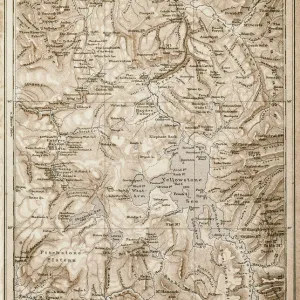
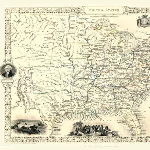
Old Map of The United States of America 1852 by Henry George Collins
This is a finely detailed map of The United States of America remastered from a rare Atlas of the World published in 1852 by Henry George Collins. Although these Henry Collins produced maps of the highest quality in his time unfortunately not the same could be said in terms of his business success. His maps were later obtained by the famous Stanford Map Company and used in their publications
Welcome to the Mapseeker Image library and enter an historic gateway to one of the largest on-line collections of Historic Maps, Nostalgic Views, Vista's and Panorama's from a World gone by.
Media ID 20347414
© Mapseeker Publishing Ltd
Collins Collins Atlas Collins Atlas Map Collins Map Map Of The Usa The United States Of America The Usa Usa Map
21"x14" (+3" Border) Fine Art Print
Discover history through the lens of exquisite detail with our Media Storehouse Fine Art Print of the Old Map of The United States of America, 1852 by Henry George Collins. This stunning print is a meticulously remastered reproduction of an original map from the rare Atlas of the World published by Henry George Collins over 160 years ago. The intricate lines and vibrant colors bring the geography and cartography of the time to life, making this a captivating addition to any home or office. Travel back in time and add a touch of history to your space with this beautiful fine art print.
21x14 image printed on 27x20 Fine Art Rag Paper with 3" (76mm) white border. Our Fine Art Prints are printed on 300gsm 100% acid free, PH neutral paper with archival properties. This printing method is used by museums and art collections to exhibit photographs and art reproductions.
Our fine art prints are high-quality prints made using a paper called Photo Rag. This 100% cotton rag fibre paper is known for its exceptional image sharpness, rich colors, and high level of detail, making it a popular choice for professional photographers and artists. Photo rag paper is our clear recommendation for a fine art paper print. If you can afford to spend more on a higher quality paper, then Photo Rag is our clear recommendation for a fine art paper print.
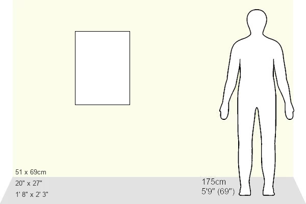
Estimated Image Size (if not cropped) is 35.5cm x 53.3cm (14" x 21")
Estimated Product Size is 50.8cm x 68.6cm (20" x 27")
These are individually made so all sizes are approximate
Artwork printed orientated as per the preview above, with portrait (vertical) orientation to match the source image.
FEATURES IN THESE COLLECTIONS
> Arts
> Photorealistic artworks
> Detailed art pieces
> Masterful detailing in art
> Maps and Charts
> Related Images
> Maps and Charts
> World
> North America
> United States of America
> Maps
> MapSeeker
> Maps of the Americas
> Maps of the United States of America
EDITORS COMMENTS
This beautifully preserved print showcases an exquisite piece of cartographic history - the "Old Map of The United States of America 1852" by Henry George Collins. Remastered from a rare Atlas of the World published in 1852, this map offers a fascinating glimpse into the past. Henry Collins was renowned for his meticulous attention to detail and his maps were considered top-notch during his time. Unfortunately, despite his exceptional craftsmanship, he did not achieve great success in business. However, fate had other plans for these remarkable maps. The prestigious Stanford Map Company recognized their value and acquired Collins' collection. These historic maps became an integral part of the company's publications, ensuring their longevity and widespread recognition. As we explore this map, we are transported back to a pivotal moment in American history. Each state is meticulously outlined with intricate details that reflect the nation's diverse landscapes and evolving borders. From bustling cities to vast wilderness areas, this map captures the essence of a rapidly expanding United States during the mid-19th century. It serves as both an educational tool and a work of art that allows us to appreciate our country's rich heritage. Whether you're a history enthusiast or simply captivated by vintage cartography, this Old Map of The United States provides an extraordinary window into America's past through Henry George Collins' skilled craftsmanship and enduring legacy.
MADE IN THE USA
Safe Shipping with 30 Day Money Back Guarantee
FREE PERSONALISATION*
We are proud to offer a range of customisation features including Personalised Captions, Color Filters and Picture Zoom Tools
SECURE PAYMENTS
We happily accept a wide range of payment options so you can pay for the things you need in the way that is most convenient for you
* Options may vary by product and licensing agreement. Zoomed Pictures can be adjusted in the Cart.