Fine Art Print > Arts > Artists > S > John Speed
Fine Art Print : Old Map of Anglo Saxon Britain by John Speed


Fine Art Prints from MapSeeker
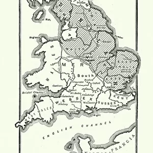
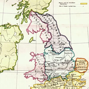
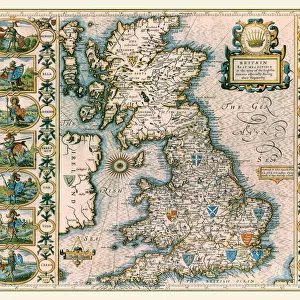
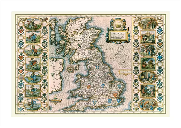
Old Map of Anglo Saxon Britain by John Speed
A facimile of John Speeds historical map of the Saxon Heptarchy originally published for the " Theatre of the Empire of Great Britain", an atlas to accompany " A History of Great Britain"
Welcome to the Mapseeker Image library and enter an historic gateway to one of the largest on-line collections of Historic Maps, Nostalgic Views, Vista's and Panorama's from a World gone by.
Media ID 20347800
© Mapseeker Publishing Ltd
Historic Map John Speed Map Speed Map Speede Map
21"x14" (+3" Border) Fine Art Print
Discover the rich history of Anglo-Saxon Britain with this stunning Fine Art Print from Media Storehouse. This exquisite reproduction is taken from John Speed's historical map of the Saxon Heptarchy, originally published in 1611 for the "Theatre of the Empire of Great Britain". The intricate details of this Old Map of Anglo-Saxon Britain beautifully illustrate the political divisions of the Anglo-Saxon kingdoms during the early modern period. Bring history to life in your home or office with this authentic and captivating piece of cartographic art.
21x14 image printed on 27x20 Fine Art Rag Paper with 3" (76mm) white border. Our Fine Art Prints are printed on 300gsm 100% acid free, PH neutral paper with archival properties. This printing method is used by museums and art collections to exhibit photographs and art reproductions.
Our fine art prints are high-quality prints made using a paper called Photo Rag. This 100% cotton rag fibre paper is known for its exceptional image sharpness, rich colors, and high level of detail, making it a popular choice for professional photographers and artists. Photo rag paper is our clear recommendation for a fine art paper print. If you can afford to spend more on a higher quality paper, then Photo Rag is our clear recommendation for a fine art paper print.
Estimated Image Size (if not cropped) is 53.3cm x 35.5cm (21" x 14")
Estimated Product Size is 68.6cm x 50.8cm (27" x 20")
These are individually made so all sizes are approximate
Artwork printed orientated as per the preview above, with landscape (horizontal) orientation to match the source image.
FEATURES IN THESE COLLECTIONS
> Arts
> Artists
> S
> John Speed
> Maps and Charts
> British Empire Maps
> Maps and Charts
> Early Maps
> Maps and Charts
> Related Images
> MapSeeker
> Maps from the British Isles
> British Isles Map PORTFOLIO
EDITORS COMMENTS
This print showcases an exquisite piece of history: the "Old Map of Anglo Saxon Britain" by John Speed. A faithful reproduction of Speed's original map, which was first published for his renowned work, "Theatre of the Empire of Great Britain" this facsimile offers a glimpse into the intricate world of the Saxon Heptarchy. With its meticulous details and artistic flair, this map takes us back in time to explore the fascinating landscape that once formed Anglo Saxon Britain. From its vibrant colors to its carefully drawn borders, every element on this map tells a story. It invites us to delve into the rich tapestry of England's past and uncover how these ancient kingdoms shaped our present. Originally created as an accompaniment to "A History of Great Britain". Speed's masterpiece is not just a geographical representation but also a historical document. The intricately labeled regions provide insight into the political divisions and power dynamics that defined this era. Whether you are an avid historian or simply captivated by cartography, this old map is sure to ignite your curiosity about Anglo Saxon Britain. Let it transport you through time as you trace the paths taken by kings and warriors across what was once known as the Saxon Heptarchy. Immerse yourself in history with this remarkable piece from John Speed – a true treasure for any lover of maps and British heritage.
MADE IN THE USA
Safe Shipping with 30 Day Money Back Guarantee
FREE PERSONALISATION*
We are proud to offer a range of customisation features including Personalised Captions, Color Filters and Picture Zoom Tools
SECURE PAYMENTS
We happily accept a wide range of payment options so you can pay for the things you need in the way that is most convenient for you
* Options may vary by product and licensing agreement. Zoomed Pictures can be adjusted in the Cart.