Fine Art Print > Europe > United Kingdom > England > Bedfordshire > Great Ouse
Fine Art Print : Old County Map of Bedfordshire 1611 by John Speed


Fine Art Prints from MapSeeker
Old County Map of Bedfordshire 1611 by John Speed
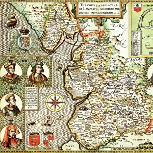
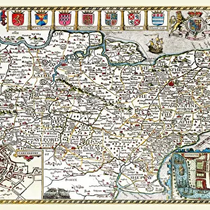
A fine reproduction of John Speeds historical map of Bedfordshire originally published for the " Theatre of the Empire of Great Britain", an atlas to accompany " a history of Great Britain".
In the top right hand corner of this beautiful map is town plan of Bedford, which includes a legend listing all the street names, churches and important buildings. Just beneath this are three coats of arms of the Dukes of Bedford. The towns of Woburn, Luton and Dunstable are clearly marked, also shown are all of the ancient deer parks of this county. In the bottom left corner of the map is a short history describing how in legend the River Ouse stopped flowing
Welcome to the Mapseeker Image library and enter an historic gateway to one of the largest on-line collections of Historic Maps, Nostalgic Views, Vista's and Panorama's from a World gone by.
Media ID 20347761
© Mapseeker Publishing Ltd
County Map County Map Of England English County Map Historic Map John Speed Map Old County Map Old English County Map Speed Map Speede Map Bedfordshire
21"x14" (+3" Border) Fine Art Print
Discover the rich history of Bedfordshire with our exquisite Old County Map of Bedfordshire 1611 by John Speed from MapSeeker. This fine art print is a meticulous reproduction of the historical map originally published in John Speed's "Theatre of the Empire of Great Britain." The intricate details of this antique map bring the past to life, transporting you back in time. Each print is carefully crafted using high-quality materials, ensuring vibrant colors and sharp details that will add character and charm to any room in your home or office. Bring a piece of historical cartography into your space with our Old County Map of Bedfordshire 1611 by John Speed from MapSeeker.
21x14 image printed on 27x20 Fine Art Rag Paper with 3" (76mm) white border. Our Fine Art Prints are printed on 300gsm 100% acid free, PH neutral paper with archival properties. This printing method is used by museums and art collections to exhibit photographs and art reproductions.
Our fine art prints are high-quality prints made using a paper called Photo Rag. This 100% cotton rag fibre paper is known for its exceptional image sharpness, rich colors, and high level of detail, making it a popular choice for professional photographers and artists. Photo rag paper is our clear recommendation for a fine art paper print. If you can afford to spend more on a higher quality paper, then Photo Rag is our clear recommendation for a fine art paper print.
Estimated Image Size (if not cropped) is 53.3cm x 35.5cm (21" x 14")
Estimated Product Size is 68.6cm x 50.8cm (27" x 20")
These are individually made so all sizes are approximate
Artwork printed orientated as per the preview above, with landscape (horizontal) orientation to match the source image.
FEATURES IN THESE COLLECTIONS
> Arts
> Artists
> S
> John Speed
> Europe
> United Kingdom
> England
> Bedfordshire
> Bedford
> Europe
> United Kingdom
> England
> Bedfordshire
> Dunstable
> Europe
> United Kingdom
> England
> Bedfordshire
> Great Ouse
> Europe
> United Kingdom
> England
> Bedfordshire
> Luton
> Europe
> United Kingdom
> England
> Bedfordshire
> Related Images
> Europe
> United Kingdom
> England
> Bedfordshire
> Woburn
> Europe
> United Kingdom
> England
> Maps
> Europe
> United Kingdom
> England
> Rivers
> Maps and Charts
> British Empire Maps
> MapSeeker
> Maps from the British Isles
> England and Counties PORTFOLIO
EDITORS COMMENTS
This stunning print showcases John Speed's Old County Map of Bedfordshire from 1611. Originally published for the "Theatre of the Empire of Great Britain" an atlas accompanying a history of Great Britain, this fine reproduction captures the intricate details and historical significance of the original map. In the top right corner, we find a town plan of Bedford, complete with a legend listing all street names, churches, and important buildings. Just below it proudly sit three coats of arms belonging to the Dukes of Bedford. The towns of Woburn, Luton, and Dunstable are clearly marked on the map as well. Additionally, all ancient deer parks in this county are thoughtfully included. A fascinating aspect can be found in the bottom left corner—a short history recounts a legendary tale where it is believed that River Ouse ceased to flow at some point in time. This intriguing detail adds an extra layer to our understanding and appreciation for this historical piece. With its old English charm and meticulous attention to detail, this print serves as both a decorative item and an educational tool. Whether you have personal ties to Bedfordshire or simply appreciate historic maps, John Speed's work offers a captivating glimpse into England's past.
MADE IN THE USA
Safe Shipping with 30 Day Money Back Guarantee
FREE PERSONALISATION*
We are proud to offer a range of customisation features including Personalised Captions, Color Filters and Picture Zoom Tools
SECURE PAYMENTS
We happily accept a wide range of payment options so you can pay for the things you need in the way that is most convenient for you
* Options may vary by product and licensing agreement. Zoomed Pictures can be adjusted in the Cart.