Fine Art Print > Europe > United Kingdom > Scotland > Maps
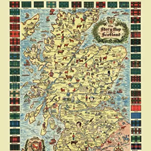
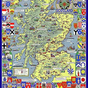
Fine Art Print : Map of the Clans and Tartans of Scotland


![]()
Fine Art Prints from MapSeeker
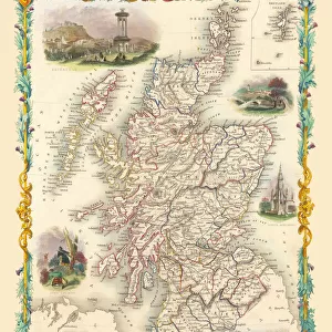
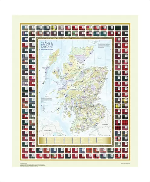
Map of the Clans and Tartans of Scotland
This map of Scotland indicates the general sphere of influence held by the clans and considerable families at the beginning of the 17th century. Some clans and families held small areas of land, and if their names are not on this map, they were not necessarily landless. The areas representing the ancient Principalities of Scotland are indicated on the map. Scotland has a rich and enduring culture steeped in history. One of the most distinctive features, of which are probably that of clanship and the predominantly Highland clans. Highland dress and the tartan is a powerful symbol of the wearerAEs pride in a Scottish ancestry and in Scotland itself. There are few, if any, other forms of national dress which can claim to make such a clear and unequivocal statement, and to be so instantly and widely recognisable
Welcome to the Mapseeker Image library and enter an historic gateway to one of the largest on-line collections of Historic Maps, Nostalgic Views, Vista's and Panorama's from a World gone by.
Media ID 20348040
20"x16" (+3" Border) Fine Art Print
Discover the rich history and tradition of Scotland with our exquisite Fine Art Print of the Map of Clans and Tartans from MapSeeker. This intricately detailed map transports you back to the beginning of the 17th century, showcasing the general spheres of influence held by the prominent Scottish clans and families. Each line and hue represents a unique story, making this print a stunning addition to any home or office. Bring a piece of Scottish heritage into your space and ignite conversations with our Fine Art Print of the Map of Clans and Tartans of Scotland.
20x16 image printed on 26x22 Fine Art Rag Paper with 3" (76mm) white border. Our Fine Art Prints are printed on 300gsm 100% acid free, PH neutral paper with archival properties. This printing method is used by museums and art collections to exhibit photographs and art reproductions.
Our fine art prints are high-quality prints made using a paper called Photo Rag. This 100% cotton rag fibre paper is known for its exceptional image sharpness, rich colors, and high level of detail, making it a popular choice for professional photographers and artists. Photo rag paper is our clear recommendation for a fine art paper print. If you can afford to spend more on a higher quality paper, then Photo Rag is our clear recommendation for a fine art paper print.
Estimated Image Size (if not cropped) is 40.6cm x 48.7cm (16" x 19.2")
Estimated Product Size is 55.9cm x 66cm (22" x 26")
These are individually made so all sizes are approximate
Artwork printed orientated as per the preview above, with portrait (vertical) orientation to match the source image.
FEATURES IN THESE COLLECTIONS
> Europe
> France
> Canton
> Landes
> Europe
> United Kingdom
> Scotland
> Maps
> Maps and Charts
> Early Maps
> Maps and Charts
> Related Images
> MapSeeker
> Maps from the British Isles
> Scotland and Counties PORTFOLIO
EDITORS COMMENTS
This print showcases the "Map of the Clans and Tartans of Scotland" offering a glimpse into the intricate web of influence held by clans and notable families during the early 17th century. While some clans and families may not be featured on this map, it does not imply their landlessness, as they might have possessed smaller territories. The map also highlights the ancient Principalities of Scotland, providing insight into the historical divisions within this culturally rich nation. Scotland's enduring heritage is deeply rooted in its unique features such as clanship and predominantly Highland clans. Among these distinct characteristics, Highland dress and tartan stand out as powerful symbols representing pride in Scottish ancestry and love for their homeland. With its unmistakable design, tartan has become an iconic representation of Scottish identity. Few other national dresses can rival its ability to make such a clear statement or enjoy such widespread recognition across borders. This print serves as a reminder of Scotland's profound history while celebrating its cultural traditions that continue to resonate with people around the world.
MADE IN THE USA
Safe Shipping with 30 Day Money Back Guarantee
FREE PERSONALISATION*
We are proud to offer a range of customisation features including Personalised Captions, Color Filters and Picture Zoom Tools
SECURE PAYMENTS
We happily accept a wide range of payment options so you can pay for the things you need in the way that is most convenient for you
* Options may vary by product and licensing agreement. Zoomed Pictures can be adjusted in the Cart.