Fine Art Print > Europe > United Kingdom > Scotland > Bute
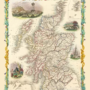
Fine Art Print : Old Map of the Counties of Argyll and Bute from the Philips Handy Atlas of 1882


![]()
Fine Art Prints from MapSeeker
Old Map of the Counties of Argyll and Bute from the Philips Handy Atlas of 1882
PHA003
Welcome to the Mapseeker Image library and enter an historic gateway to one of the largest on-line collections of Historic Maps, Nostalgic Views, Vista's and Panorama's from a World gone by.
Media ID 20346953
County Map County Map Of Scotland Historic Map Old County Map Old Scottish County Map Scottish County Map Argyle Argyleshire Bute
20"x16" (+3" Border) Fine Art Print
Step back in time with our exquisite Old Map of Argyll and Bute from the Philips Handy Atlas of 1882. Part of our Fine Art Prints collection from Media Storehouse, this beautifully detailed map transports you to a bygone era. The intricate lines and vibrant colors bring the history of Argyll and Bute to life, making it a stunning addition to any home or office. Printed on high-quality archival paper, this fine art print is not only a beautiful decor piece but also a valuable historical document. Bring a touch of the past into your space with our Old Map of Argyll and Bute from Media Storehouse.
20x16 image printed on 26x22 Fine Art Rag Paper with 3" (76mm) white border. Our Fine Art Prints are printed on 300gsm 100% acid free, PH neutral paper with archival properties. This printing method is used by museums and art collections to exhibit photographs and art reproductions.
Our fine art prints are high-quality prints made using a paper called Photo Rag. This 100% cotton rag fibre paper is known for its exceptional image sharpness, rich colors, and high level of detail, making it a popular choice for professional photographers and artists. Photo rag paper is our clear recommendation for a fine art paper print. If you can afford to spend more on a higher quality paper, then Photo Rag is our clear recommendation for a fine art paper print.
Estimated Image Size (if not cropped) is 40.6cm x 50.8cm (16" x 20")
Estimated Product Size is 55.9cm x 66cm (22" x 26")
These are individually made so all sizes are approximate
Artwork printed orientated as per the preview above, with portrait (vertical) orientation to match the source image.
FEATURES IN THESE COLLECTIONS
> Europe
> United Kingdom
> Scotland
> Argyll
> Europe
> United Kingdom
> Scotland
> Bute
> Europe
> United Kingdom
> Scotland
> Fife
> Related Images
> Europe
> United Kingdom
> Scotland
> Maps
> Maps and Charts
> Early Maps
> Maps and Charts
> Related Images
> MapSeeker
> Maps from the British Isles
> Scotland and Counties PORTFOLIO
EDITORS COMMENTS
This print showcases an exquisite piece of history - the Old Map of the Counties of Argyll and Bute from the Philips Handy Atlas of 1882 (PHA003). Transporting us back in time, this Scottish county map offers a glimpse into the past, shedding light on the rich heritage and geographical intricacies of Argyll and Bute. With meticulous detail, this old county map reveals the boundaries, towns, villages, rivers, and mountains that defined these regions over a century ago. Its vintage charm is evident in every stroke and contour; it serves as a testament to cartographic artistry during that era. The historical significance of this map extends beyond its aesthetic appeal. It allows us to trace Scotland's evolution by exploring Argyle County's vast landscapes or delving into Buteshire's quaint corners. Whether you are an avid historian or simply intrigued by maps' allure, this print offers a fascinating window into Scotland's past. As we gaze upon this remarkable artifact from yesteryears, let our imagination wander through ancient castles nestled amidst rolling hills or envision bustling marketplaces once teeming with life. This historic map encapsulates not only geographic information but also stories waiting to be discovered. Displaying this print will undoubtedly spark conversations about Scottish history while adding character to any space. Let it serve as a reminder that even within modernity lies traces of our ancestors' footsteps – their triumphs, struggles, and enduring legacy etched onto every inch of this old county
MADE IN THE USA
Safe Shipping with 30 Day Money Back Guarantee
FREE PERSONALISATION*
We are proud to offer a range of customisation features including Personalised Captions, Color Filters and Picture Zoom Tools
SECURE PAYMENTS
We happily accept a wide range of payment options so you can pay for the things you need in the way that is most convenient for you
* Options may vary by product and licensing agreement. Zoomed Pictures can be adjusted in the Cart.