Fine Art Print > Arts > Artists > H > Jodocus Hondius
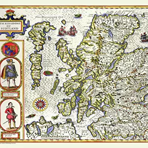
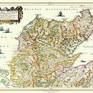
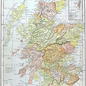
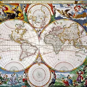
Fine Art Print : Old Map of Scotland 1635 by Willem & Johan Blaeu from the Theatrum Orbis Terrarum


![]()
Fine Art Prints from MapSeeker
Old Map of Scotland 1635 by Willem & Johan Blaeu from the Theatrum Orbis Terrarum
This detailed and most attractive reproduction map of Scotland has been carefully art worked from a scan of an antique original. The famous firm of Dutch cartographers and publishers was established in the late 16th century by Willem Janszoon Blaeu in Amsterdam. Blaeu was a maker of globes and scientific instruments and purchased some of his early map plates from Jodocus Hondius. From this small beginning was to emerge one of the largest and most prolific map publishing houses of the seventeenth century
Welcome to the Mapseeker Image library and enter an historic gateway to one of the largest on-line collections of Historic Maps, Nostalgic Views, Vista's and Panorama's from a World gone by.
Media ID 20348011
Blaeu Blaeu Family Blaue Map Historic Map Johan Blaeu Johan Blaeu Map Old Blaue Map Old Map Of Scotland Old Scotland Map Old Scottish Map Scotland Scotland Map Scottish Map
21"x14" (+3" Border) Fine Art Print
Discover the rich history of Scotland with our exquisite Fine Art Print of the Old Map of Scotland 1635 by Willem & Johan Blaeu from Theatrum Orbis Terrarum. This detailed and captivating reproduction, sourced from MapSeeker, showcases the intricate cartography of the time with meticulous artistry. Bring the past to life in your home or office with this beautiful and authentic piece of cartographic history.
21x14 image printed on 27x20 Fine Art Rag Paper with 3" (76mm) white border. Our Fine Art Prints are printed on 300gsm 100% acid free, PH neutral paper with archival properties. This printing method is used by museums and art collections to exhibit photographs and art reproductions.
Our fine art prints are high-quality prints made using a paper called Photo Rag. This 100% cotton rag fibre paper is known for its exceptional image sharpness, rich colors, and high level of detail, making it a popular choice for professional photographers and artists. Photo rag paper is our clear recommendation for a fine art paper print. If you can afford to spend more on a higher quality paper, then Photo Rag is our clear recommendation for a fine art paper print.
Estimated Image Size (if not cropped) is 53.3cm x 35.5cm (21" x 14")
Estimated Product Size is 68.6cm x 50.8cm (27" x 20")
These are individually made so all sizes are approximate
Artwork printed orientated as per the preview above, with landscape (horizontal) orientation to match the source image.
FEATURES IN THESE COLLECTIONS
> Arts
> Artists
> B
> Willem Blaeu
> Arts
> Artists
> H
> Jodocus Hondius
> Arts
> Photorealistic artworks
> Detailed art pieces
> Masterful detailing in art
> Europe
> United Kingdom
> Scotland
> Maps
> Maps and Charts
> Early Maps
> Maps and Charts
> Willem Janszoon Blaeu
> MapSeeker
> Maps from the British Isles
> Scotland and Counties PORTFOLIO
EDITORS COMMENTS
This beautifully crafted reproduction of the "Old Map of Scotland 1635" by Willem and Johan Blaeu takes us back in time to explore the rich history of this enchanting land. Carefully art worked from an antique original, every intricate detail has been preserved, allowing us to delve into the past and discover Scotland's captivating story. The renowned Dutch cartographers and publishers, Willem Janszoon Blaeu and his son Johan, established their firm in Amsterdam during the late 16th century. Initially specializing in globes and scientific instruments, they soon expanded their repertoire to include map publishing. This marked the beginning of a remarkable journey that would see them become one of the largest and most prolific map publishing houses of the seventeenth century. As we gaze upon this historic map, we are transported through time as if stepping into a portal that reveals Scotland's ancient landscapes. From its rugged Highlands to its picturesque Lowlands, every contour is meticulously depicted with precision and artistic flair. The rivers flow gracefully across parchment-like paper while cities emerge as tiny clusters of buildings nestled amidst nature's grandeur. This old Scottish map serves not only as a testament to the skillful craftsmanship of Willem and Johan Blaeu but also as a window into Scotland's past. It invites us to embark on a visual journey where history intertwines with geography, offering glimpses into forgotten tales waiting to be rediscovered. Whether you are an avid historian or simply captivated by maps' allure, this exquisite
MADE IN THE USA
Safe Shipping with 30 Day Money Back Guarantee
FREE PERSONALISATION*
We are proud to offer a range of customisation features including Personalised Captions, Color Filters and Picture Zoom Tools
SECURE PAYMENTS
We happily accept a wide range of payment options so you can pay for the things you need in the way that is most convenient for you
* Options may vary by product and licensing agreement. Zoomed Pictures can be adjusted in the Cart.