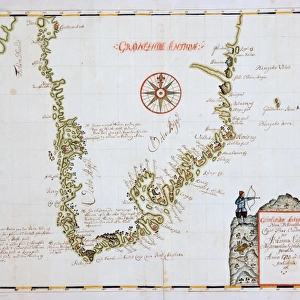
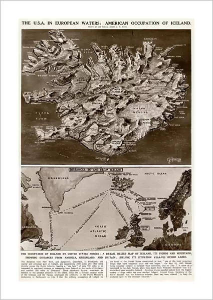
Fine Art Print : American occupation of Iceland by G. H. Davis

![]()
Fine Art Prints from Mary Evans Picture Library
American occupation of Iceland by G. H. Davis
The USA in European waters: American occupation of Iceland during the Second World War. A detailed relief map of Iceland, its fjords and mountains, showing distances from America, Greenland and Britain. Another map showing its position in relation to other countries. Date: 1941
Mary Evans Picture Library makes available wonderful images created for people to enjoy over the centuries
Media ID 14125661
© Illustrated London News Ltd/Mary Evans
1941 Arctic Atlantic Baltic Continent Countries Davis Detailed Distances Fjords Greenland Iceland Labrador Maps Newfoundland Norway Occupation Position Relation Scandinavia Sweden Waters
21"x14" (+3" Border) Fine Art Print
Step back in time with our exquisite Fine Art Print of "The USA in European Waters: American Occupation of Iceland during the Second World War" by G.H. Davis. This captivating print, sourced from Mary Evans Prints Online, offers a unique glimpse into history with its intricate depiction of Iceland's terrain during the American occupation. The detailed relief map showcases the fjords, mountains, and distances from America, providing a fascinating perspective on this significant historical event. Bring history into your home or office with this beautiful and thought-provoking addition to your collection.
21x14 image printed on 27x20 Fine Art Rag Paper with 3" (76mm) white border. Our Fine Art Prints are printed on 300gsm 100% acid free, PH neutral paper with archival properties. This printing method is used by museums and art collections to exhibit photographs and art reproductions.
Our fine art prints are high-quality prints made using a paper called Photo Rag. This 100% cotton rag fibre paper is known for its exceptional image sharpness, rich colors, and high level of detail, making it a popular choice for professional photographers and artists. Photo rag paper is our clear recommendation for a fine art paper print. If you can afford to spend more on a higher quality paper, then Photo Rag is our clear recommendation for a fine art paper print.
Estimated Image Size (if not cropped) is 35.5cm x 53.3cm (14" x 21")
Estimated Product Size is 50.8cm x 68.6cm (20" x 27")
These are individually made so all sizes are approximate
Artwork printed orientated as per the preview above, with portrait (vertical) orientation to match the source image.
EDITORS COMMENTS
This evocative print, created by renowned cartographer G.H. Davis in 1941, offers a fascinating glimpse into the strategic importance of Iceland during the Second World War. Titled "The USA in European Waters: American Occupation of Iceland," the image features two maps meticulously detailing the topography and geographical position of Iceland. The first map is a detailed relief map, highlighting the island's rugged terrain, with its fjords, mountains, and glaciers. The map also includes distance measurements from key locations, such as America, Greenland, and Britain, providing context to the island's unique position in the North Atlantic. The second map presents Iceland's location in relation to other European countries, including Norway, Sweden, and Denmark, as well as the United States, Greenland, and Newfoundland. The map also includes the Arctic, Baltic, and Atlantic Oceans, emphasizing Iceland's significance as a gateway to the North Atlantic and its proximity to key European and North American territories. At the time of this map's creation, Iceland was under American occupation, with the United States having taken control of the island in May 1940, following the withdrawal of the British. The occupation was a strategic move to secure the North Atlantic against potential Axis powers, particularly Germany, and to protect the crucial shipping lanes between Europe and North America. This print serves as a poignant reminder of the complex geopolitical dynamics of the Second World War and the role that Iceland played in the larger conflict. Its intricate detail and historical significance make it an essential addition to any collection focused on the history of the Second World War, European history, or cartography.
MADE IN THE USA
Safe Shipping with 30 Day Money Back Guarantee
FREE PERSONALISATION*
We are proud to offer a range of customisation features including Personalised Captions, Color Filters and Picture Zoom Tools
SECURE PAYMENTS
We happily accept a wide range of payment options so you can pay for the things you need in the way that is most convenient for you
* Options may vary by product and licensing agreement. Zoomed Pictures can be adjusted in the Cart.