Fine Art Print > Maps and Charts > British Empire Maps
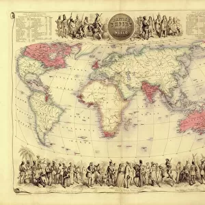
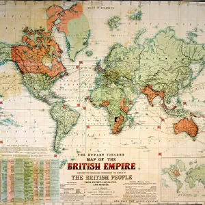
Fine Art Print : British Empire Map 1880


![]()
Fine Art Prints from Mary Evans Picture Library
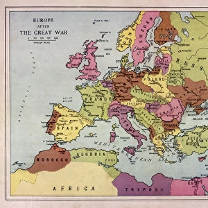
British Empire Map 1880
Map showing the extent of the British Empire circa 1880
Mary Evans Picture Library makes available wonderful images created for people to enjoy over the centuries
Media ID 608738
© Mary Evans Picture Library 2015 - https://copyrighthub.org/s0/hub1/creation/maryevans/MaryEvansPictureID/10113710
21"x14" (+3" Border) Fine Art Print
Step into the past with our exquisite Fine Art Print of the British Empire Map 1880 from Mary Evans Picture Library. This captivating print, sourced from Mary Evans Prints Online, offers a fascinating glimpse into history, showcasing the vast expanse of the British Empire at the height of its power and influence. With meticulous attention to detail, the intricate lines and borders of this antique map come to life, transporting you back in time. Perfect for history enthusiasts, world explorers, or those seeking to add a touch of timeless charm to their walls, this Fine Art Print is a must-have addition to any collection. Experience the rich history of the British Empire like never before with this stunning piece of art.
21x14 image printed on 27x20 Fine Art Rag Paper with 3" (76mm) white border. Our Fine Art Prints are printed on 300gsm 100% acid free, PH neutral paper with archival properties. This printing method is used by museums and art collections to exhibit photographs and art reproductions.
Our fine art prints are high-quality prints made using a paper called Photo Rag. This 100% cotton rag fibre paper is known for its exceptional image sharpness, rich colors, and high level of detail, making it a popular choice for professional photographers and artists. Photo rag paper is our clear recommendation for a fine art paper print. If you can afford to spend more on a higher quality paper, then Photo Rag is our clear recommendation for a fine art paper print.
Estimated Image Size (if not cropped) is 53.3cm x 33.1cm (21" x 13")
Estimated Product Size is 68.6cm x 50.8cm (27" x 20")
These are individually made so all sizes are approximate
Artwork printed orientated as per the preview above, with landscape (horizontal) orientation to match the source image.
FEATURES IN THESE COLLECTIONS
> Maps and Charts
> British Empire Maps
> Maps and Charts
> Early Maps
> Maps and Charts
> Related Images
> Maps and Charts
> World
EDITORS COMMENTS
This stunning print showcases a detailed map of the British Empire in 1880, capturing the vast extent of British colonial power during this pivotal period in history. The intricate details and vibrant colors bring to life the various territories and regions under British rule, from India to Africa to Australia and beyond.
The red shading on the map highlights the sheer magnitude of influence that Britain held over a significant portion of the world at that time. It serves as a visual representation of imperial dominance and control, reflecting an era when Britannia truly ruled the waves.
As we gaze upon this historical artifact, we are transported back to a time when empires were built through conquest and colonization. The legacy of the British Empire is complex and multifaceted, with both positive contributions and negative consequences felt across the globe.
This map is not just a geographical representation but also a symbol of power, ambition, and imperialism. It reminds us of an era when borders were redrawn by force, cultures clashed, and millions of lives were forever changed by colonial expansion.
Through this print from Mary Evans Picture Library, we are given a glimpse into a world shaped by empire-building ambitions – a world where Britannia's reach truly knew no bounds.
MADE IN THE USA
Safe Shipping with 30 Day Money Back Guarantee
FREE PERSONALISATION*
We are proud to offer a range of customisation features including Personalised Captions, Color Filters and Picture Zoom Tools
SECURE PAYMENTS
We happily accept a wide range of payment options so you can pay for the things you need in the way that is most convenient for you
* Options may vary by product and licensing agreement. Zoomed Pictures can be adjusted in the Cart.


![Glasgow Central Station. Caledonian Railway [N. D]](/sq/229/glasgow-central-station-caledonian-railway-n-13155169.jpg.webp)