Fine Art Print > Europe > Italy > Maps
Fine Art Print : Italy Map Pre-Unity


![]()
Fine Art Prints from Mary Evans Picture Library
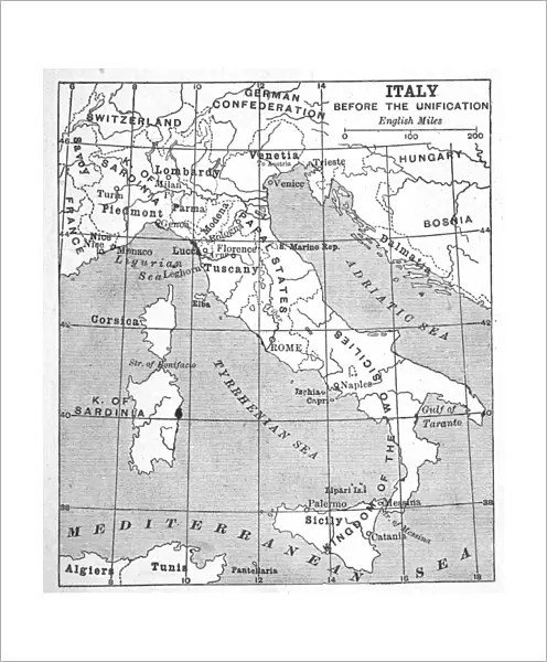
Italy Map Pre-Unity
A map of Italy prior to unification
Mary Evans Picture Library makes available wonderful images created for people to enjoy over the centuries
Media ID 4369289
© Mary Evans Picture Library 2015 - https://copyrighthub.org/s0/hub1/creation/maryevans/MaryEvansPictureID/10125159
1850 Maps Papal Prior Unification Unity
20"x16" (+3" Border) Fine Art Print
Discover the rich history and cultural beauty of Italy with our exquisite Fine Art Prints from Media Storehouse. This captivating piece, "Italy Map Pre-Unity," is an evocative representation of Italy as it existed prior to its unification in 1861. Sourced from the esteemed Mary Evans Prints Online, this Rights Managed image transports you back in time, inviting you to explore the diverse regions and intriguing history of the Bel Paese. Add a touch of timeless elegance to your home or office with this stunning, high-quality print. Let the allure of Italy's past captivate you every day.
20x16 image printed on 26x22 Fine Art Rag Paper with 3" (76mm) white border. Our Fine Art Prints are printed on 300gsm 100% acid free, PH neutral paper with archival properties. This printing method is used by museums and art collections to exhibit photographs and art reproductions.
Our fine art prints are high-quality prints made using a paper called Photo Rag. This 100% cotton rag fibre paper is known for its exceptional image sharpness, rich colors, and high level of detail, making it a popular choice for professional photographers and artists. Photo rag paper is our clear recommendation for a fine art paper print. If you can afford to spend more on a higher quality paper, then Photo Rag is our clear recommendation for a fine art paper print.
Estimated Image Size (if not cropped) is 40.6cm x 46.3cm (16" x 18.2")
Estimated Product Size is 55.9cm x 66cm (22" x 26")
These are individually made so all sizes are approximate
Artwork printed orientated as per the preview above, with portrait (vertical) orientation to match the source image.
FEATURES IN THESE COLLECTIONS
> Europe
> Italy
> Related Images
> Maps and Charts
> Early Maps
> Maps and Charts
> Italy
> Maps and Charts
> Related Images
EDITORS COMMENTS
This print showcases a historical map of Italy prior to unification, offering a glimpse into the intricate political landscape of the region in 1850. The map depicts the various states and territories that existed before Italy became a unified nation, highlighting the complex web of alliances and rivalries that characterized this period in history.
One can't help but be drawn in by the detailed cartography and elegant design of this pre-unity Italian map. From the Papal States to the Kingdom of Sardinia, each region is clearly delineated with precision and care. It's fascinating to see how these disparate entities eventually came together to form modern-day Italy, shedding light on the long and arduous process of nation-building.
As we study this map, we are reminded of the struggles and triumphs that shaped Italy's journey towards unity. The rich tapestry of history is laid out before us, inviting us to delve deeper into the stories behind each state and its role in shaping Italy's destiny.
Whether you're a history buff or simply appreciate fine craftsmanship, this print is sure to captivate your imagination and transport you back in time to an era when Italy was not yet united but poised on the brink of transformation.
MADE IN THE USA
Safe Shipping with 30 Day Money Back Guarantee
FREE PERSONALISATION*
We are proud to offer a range of customisation features including Personalised Captions, Color Filters and Picture Zoom Tools
SECURE PAYMENTS
We happily accept a wide range of payment options so you can pay for the things you need in the way that is most convenient for you
* Options may vary by product and licensing agreement. Zoomed Pictures can be adjusted in the Cart.