Fine Art Print > Maps and Charts > Early Maps
Fine Art Print : Map / Asia / Mongol Empire


Fine Art Prints from Mary Evans Picture Library
Map / Asia / Mongol Empire
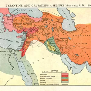
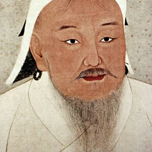
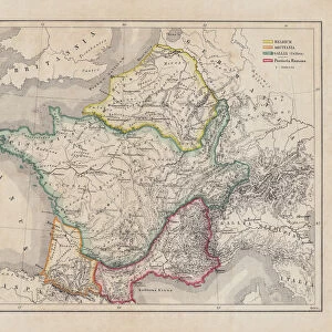
The Mongol Empire at its greatest extent : commenced by Genghis Khan in the 13th century, it was enlarged by Kublai Khan but broke up after about 1380
Mary Evans Picture Library makes available wonderful images created for people to enjoy over the centuries
Media ID 584825
© Mary Evans Picture Library 2015 - https://copyrighthub.org/s0/hub1/creation/maryevans/MaryEvansPictureID/10038070
1300 1380 13th Broke Commenced Enlarged Extent Genghis Greatest Khan Kublai Maps Mongol
20"x16" (+3" Border) Fine Art Print
Discover the rich history of the Mongol Empire with our stunning Fine Art Print from Mary Evans Picture Library. This exquisite Map of Asia, depicting the Mongol Empire at its greatest extent, transports you back in time to the 13th century. Founded by Genghis Khan and later expanded by Kublai Khan, this powerful empire spanned continents and left an indelible mark on history. Add this beautiful and educational print to your home or office to inspire curiosity and ignite conversation. Order now and bring a piece of history into your space.
20x16 image printed on 26x22 Fine Art Rag Paper with 3" (76mm) white border. Our Fine Art Prints are printed on 300gsm 100% acid free, PH neutral paper with archival properties. This printing method is used by museums and art collections to exhibit photographs and art reproductions.
Our fine art prints are high-quality prints made using a paper called Photo Rag. This 100% cotton rag fibre paper is known for its exceptional image sharpness, rich colors, and high level of detail, making it a popular choice for professional photographers and artists. Photo rag paper is our clear recommendation for a fine art paper print. If you can afford to spend more on a higher quality paper, then Photo Rag is our clear recommendation for a fine art paper print.
Estimated Image Size (if not cropped) is 50.8cm x 37.2cm (20" x 14.6")
Estimated Product Size is 66cm x 55.9cm (26" x 22")
These are individually made so all sizes are approximate
Artwork printed orientated as per the preview above, with landscape (horizontal) orientation to match the source image.
FEATURES IN THESE COLLECTIONS
> Asia
> Related Images
> Maps and Charts
> Early Maps
> Maps and Charts
> Related Images
> Popular Themes
> Maps and Charts
EDITORS COMMENTS
This map print showcases the Mongol Empire at its greatest extent during the 13th century, a historical period marked by the remarkable reigns of Genghis Khan and Kublai Khan. The Mongol Empire, which commenced under Genghis Khan in the early 13th century, was initially a small nomadic confederation in the Mongolian plateau. However, under Genghis Khan's leadership, it grew into a formidable military power that conquered vast territories in Asia and Eastern Europe. Genghis Khan's successor, Ögödei Khan, continued the empire's expansion, and it was further enlarged under Kublai Khan in the late 13th century. At its peak, the Mongol Empire stretched from the Pacific Ocean in the east to the Caspian Sea in the west, and from the Arctic Ocean in the north to the Indian subcontinent in the south. The Mongol Empire's cultural and economic influence extended far beyond its borders, and it facilitated the exchange of goods, ideas, and technologies between different civilizations. The map illustrates the empire's territorial reach, with various regions labeled, including China, Persia, India, Russia, and the Middle East. This map is an invaluable historical resource, providing a visual representation of the Mongol Empire's vast territorial extent during the 13th century. It serves as a reminder of the empire's significant impact on world history and its lasting legacy. The intricate details and vibrant colors bring the map to life, making it an essential addition to any history or geography collection.
MADE IN THE USA
Safe Shipping with 30 Day Money Back Guarantee
FREE PERSONALISATION*
We are proud to offer a range of customisation features including Personalised Captions, Color Filters and Picture Zoom Tools
SECURE PAYMENTS
We happily accept a wide range of payment options so you can pay for the things you need in the way that is most convenient for you
* Options may vary by product and licensing agreement. Zoomed Pictures can be adjusted in the Cart.