Fine Art Print > Arts > Artists > O > Abraham Ortelius
Fine Art Print : Map of Central and South America. Theatrum Orbis Terrarum by


![]()
Fine Art Prints from Mary Evans Picture Library
Map of Central and South America. Theatrum Orbis Terrarum by
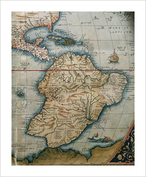
Map of Central and South America. Theatrum Orbis Terrarum by Abraham Ortelius (1527-1598). First Edition. Antwerp, 1574
Mary Evans Picture Library makes available wonderful images created for people to enjoy over the centuries
Media ID 14331728
© Thaliastock / Mary Evans
1574 Abraham Americas Antwerp Atlas Caribbean Carthography Cartographic Cartography Catalonia Continent Edition Flanders Flemish Geography Orbis Ortelius Ortels Terrarum Theatrum
20"x16" (+3" Border) Fine Art Print
Discover the rich cultural and geographical wonders of Central and South America with our exquisite fine art print from the Media Storehouse collection. This captivating map, titled "Theatrum Orbis Terrarum," is an original first edition created by the renowned cartographer Abraham Ortelius in 1574. Known for its intricate detail and accuracy, this masterpiece showcases the vast expanse of Central and South America as it was understood during the Renaissance era. Bring history and art into your home or office with this stunning, museum-quality print, now available through Mary Evans Prints Online. Rights managed.
20x16 image printed on 26x22 Fine Art Rag Paper with 3" (76mm) white border. Our Fine Art Prints are printed on 300gsm 100% acid free, PH neutral paper with archival properties. This printing method is used by museums and art collections to exhibit photographs and art reproductions.
Our fine art prints are high-quality prints made using a paper called Photo Rag. This 100% cotton rag fibre paper is known for its exceptional image sharpness, rich colors, and high level of detail, making it a popular choice for professional photographers and artists. Photo rag paper is our clear recommendation for a fine art paper print. If you can afford to spend more on a higher quality paper, then Photo Rag is our clear recommendation for a fine art paper print.
Estimated Image Size (if not cropped) is 40.6cm x 50.7cm (16" x 20")
Estimated Product Size is 55.9cm x 66cm (22" x 26")
These are individually made so all sizes are approximate
Artwork printed orientated as per the preview above, with portrait (vertical) orientation to match the source image.
FEATURES IN THESE COLLECTIONS
> Arts
> Artists
> O
> Abraham Ortelius
> Arts
> Artists
> O
> Oceanic Oceanic
> Europe
> Belgium
> Related Images
> Europe
> Spain
> Related Images
> Maps and Charts
> Abraham Ortelius
EDITORS COMMENTS
This stunning map print, titled "Theatrum Orbis Terrarum" or "The Theatre of the World," is a masterpiece of cartography from the 16th century. Created by the renowned Flemish cartographer Abraham Ortelius (1527-1598) in Antwerp, Belgium, in 1574, this map is considered the first modern atlas. The intricately detailed map depicts Central and South America, with a focus on the Caribbean region. Ortelius' map showcases the latest geographical knowledge of the time, reflecting the expanding European exploration and colonization of the Americas. The map includes various islands in the Caribbean Sea, the Gulf of Mexico, and the Atlantic Ocean. The detailed rendering of the coastlines, topography, and political divisions of the continents is remarkable for its accuracy, given the challenges of exploration and communication during the 16th century. One of the most striking features of this map is the depiction of ships and vessels navigating the waters, providing a sense of the maritime activity that characterized the Age of Discovery. The map also includes various annotations, such as the names of different regions and countries, as well as the names of explorers and conquerors. This map, which is part of a larger atlas, holds significant historical value as it represents a major milestone in the development of cartography and geographical knowledge. It is a testament to the curiosity and exploration that characterized the early modern period and the desire to understand the world around us. The map is a beautiful and fascinating reminder of the rich history of cartography and the importance of geographical knowledge in shaping our understanding of the world.
MADE IN THE USA
Safe Shipping with 30 Day Money Back Guarantee
FREE PERSONALISATION*
We are proud to offer a range of customisation features including Personalised Captions, Color Filters and Picture Zoom Tools
SECURE PAYMENTS
We happily accept a wide range of payment options so you can pay for the things you need in the way that is most convenient for you
* Options may vary by product and licensing agreement. Zoomed Pictures can be adjusted in the Cart.