Fine Art Print > Asia > Turkey > Related Images
Fine Art Print : Map of Greece, 1792


![]()
Fine Art Prints from Mary Evans Picture Library
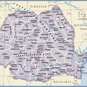
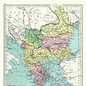
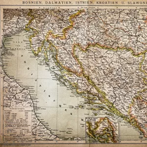
Map of Greece, 1792
Map of Greece and Greek islands plus Romania (which appears on this map to be incorrectly labelled or positioned south of Bulgaria), Macedonia, Albania and parts of Turkey and Italy. (Detail of image 10074527) Date: 1792
Mary Evans Picture Library makes available wonderful images created for people to enjoy over the centuries
Media ID 7188023
© Mary Evans Picture Library 2015 - https://copyrighthub.org/s0/hub1/creation/maryevans/MaryEvansPictureID/10527528
1790s 1792 Albania Macedonia Maps Romania
20"x16" (+3" Border) Fine Art Print
Discover the rich history and culture of Greece with our exquisite Fine Art Print of the Map of Greece from 1792, available at Media Storehouse. This beautifully detailed map, sourced from Mary Evans Prints Online, showcases the geography of Greece during this period, including the Greek islands, Macedonia, Albania, Romania, parts of Turkey, and Italy. Transport yourself back in time and add a touch of historical charm to your home or office decor. Our Fine Art Prints are available for licensing and can be customized to fit your specific needs. Order yours today and bring a piece of history into your space.
20x16 image printed on 26x22 Fine Art Rag Paper with 3" (76mm) white border. Our Fine Art Prints are printed on 300gsm 100% acid free, PH neutral paper with archival properties. This printing method is used by museums and art collections to exhibit photographs and art reproductions.
Our fine art prints are high-quality prints made using a paper called Photo Rag. This 100% cotton rag fibre paper is known for its exceptional image sharpness, rich colors, and high level of detail, making it a popular choice for professional photographers and artists. Photo rag paper is our clear recommendation for a fine art paper print. If you can afford to spend more on a higher quality paper, then Photo Rag is our clear recommendation for a fine art paper print.
Estimated Image Size (if not cropped) is 50.5cm x 40.6cm (19.9" x 16")
Estimated Product Size is 66cm x 55.9cm (26" x 22")
These are individually made so all sizes are approximate
Artwork printed orientated as per the preview above, with landscape (horizontal) orientation to match the source image.
FEATURES IN THESE COLLECTIONS
> Asia
> Turkey
> Related Images
> Europe
> Albania
> Related Images
> Europe
> Bulgaria
> Related Images
> Europe
> Greece
> Related Images
MADE IN THE USA
Safe Shipping with 30 Day Money Back Guarantee
FREE PERSONALISATION*
We are proud to offer a range of customisation features including Personalised Captions, Color Filters and Picture Zoom Tools
SECURE PAYMENTS
We happily accept a wide range of payment options so you can pay for the things you need in the way that is most convenient for you
* Options may vary by product and licensing agreement. Zoomed Pictures can be adjusted in the Cart.