Fine Art Print > Historic > Ancient civilizations > Roman Empire > Roman art
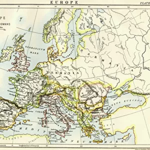
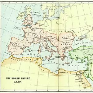
Fine Art Print : Map of the Roman Empire


Fine Art Prints from Mary Evans Picture Library
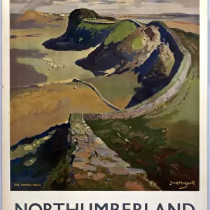
Map of the Roman Empire
A map showing the extent of the Roman Empire
Mary Evans Picture Library makes available wonderful images created for people to enjoy over the centuries
Media ID 600232
© Mary Evans Picture Library 2015 - https://copyrighthub.org/s0/hub1/creation/maryevans/MaryEvansPictureID/10137105
Civilisation Conquest Control Extensive Extent Maps Romans
21"x14" (+3" Border) Fine Art Print
Discover the rich history and grandeur of the ancient Roman Empire with our exquisite selection of Fine Art Prints from Media Storehouse and Mary Evans Picture Library. This captivating Map of the Roman Empire, meticulously reproduced from the Mary Evans Prints Online archive, transports you back in time. Each print is carefully crafted using high-quality materials and vibrant colors, ensuring a stunning addition to your home or office. Relive the glory days of the Roman Empire and elevate your space with this timeless piece of art.
21x14 image printed on 27x20 Fine Art Rag Paper with 3" (76mm) white border. Our Fine Art Prints are printed on 300gsm 100% acid free, PH neutral paper with archival properties. This printing method is used by museums and art collections to exhibit photographs and art reproductions.
Our fine art prints are high-quality prints made using a paper called Photo Rag. This 100% cotton rag fibre paper is known for its exceptional image sharpness, rich colors, and high level of detail, making it a popular choice for professional photographers and artists. Photo rag paper is our clear recommendation for a fine art paper print. If you can afford to spend more on a higher quality paper, then Photo Rag is our clear recommendation for a fine art paper print.
Estimated Image Size (if not cropped) is 53.3cm x 35.5cm (21" x 14")
Estimated Product Size is 68.6cm x 50.8cm (27" x 20")
These are individually made so all sizes are approximate
Artwork printed orientated as per the preview above, with landscape (horizontal) orientation to match the source image.
FEATURES IN THESE COLLECTIONS
> Arts
> Artists
> R
> Roman Roman
> Europe
> Related Images
> Historic
> Ancient civilizations
> Roman Empire
> Roman art
> Maps and Charts
> Early Maps
> Maps and Charts
> Related Images
EDITORS COMMENTS
This stunning print of a Map of the Roman Empire offers a fascinating glimpse into the extent of one of history's most powerful civilizations. Dating back to the 2nd century, this historical map showcases the vast conquests and control achieved by the Romans across Europe and beyond. The intricate details on display highlight not only the sheer size of their empire but also the sophistication and organization that allowed them to maintain such extensive territories.
As we study this map, we can't help but marvel at how far-reaching Roman influence was during this era. From Britain to North Africa, from Spain to Asia Minor, every corner of their empire is meticulously depicted, showcasing just how advanced their civilization was in terms of military strategy, governance, and cultural assimilation.
Through maps like these, we are able to connect with our past in a tangible way, gaining insight into the complexities and achievements of ancient societies. This particular print from Mary Evans Picture Library serves as a valuable educational tool for historians and enthusiasts alike who wish to delve deeper into understanding the legacy left behind by one of history's greatest empires.
MADE IN THE USA
Safe Shipping with 30 Day Money Back Guarantee
FREE PERSONALISATION*
We are proud to offer a range of customisation features including Personalised Captions, Color Filters and Picture Zoom Tools
SECURE PAYMENTS
We happily accept a wide range of payment options so you can pay for the things you need in the way that is most convenient for you
* Options may vary by product and licensing agreement. Zoomed Pictures can be adjusted in the Cart.