Fine Art Print > Oceania > Australia > Maps
Fine Art Print : Maps / Australia 1850S

![]()
Fine Art Prints from Mary Evans Picture Library
Maps / Australia 1850S
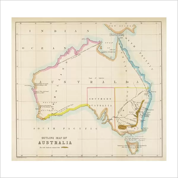
Map showing the location of the GOLDFIELDS, so presumably made fairly soon after the start of the Australian Gold Rush in 1851
Mary Evans Picture Library makes available wonderful images created for people to enjoy over the centuries
Media ID 576480
© Mary Evans Picture Library 2015 - https://copyrighthub.org/s0/hub1/creation/maryevans/MaryEvansPictureID/10015335
1850s 1851 Australian Fairly Gold Fields Maps Rush Start Made
20"x20" (+3" Border) Fine Art Print
Step back in time with our exquisite selection of Fine Art Prints from Media Storehouse, featuring this captivating map of Australia from the 1850s, sourced from Mary Evans Prints Online. This intricately detailed map showcases the location of the Goldfields, a reflection of the era's rich history and the beginning of the Australian Gold Rush in 1851. Add a touch of history and character to your home or office with this stunning piece of art, perfect for history enthusiasts, collectors, or anyone who appreciates the beauty of vintage maps.
20x20 image printed on 26x26 Fine Art Rag Paper with 3" (76mm) white border. Our Fine Art Prints are printed on 300gsm 100% acid free, PH neutral paper with archival properties. This printing method is used by museums and art collections to exhibit photographs and art reproductions.
Our fine art prints are high-quality prints made using a paper called Photo Rag. This 100% cotton rag fibre paper is known for its exceptional image sharpness, rich colors, and high level of detail, making it a popular choice for professional photographers and artists. Photo rag paper is our clear recommendation for a fine art paper print. If you can afford to spend more on a higher quality paper, then Photo Rag is our clear recommendation for a fine art paper print.
Estimated Image Size (if not cropped) is 50.8cm x 47.1cm (20" x 18.5")
Estimated Product Size is 66cm x 66cm (26" x 26")
These are individually made so all sizes are approximate
Artwork printed orientated as per the preview above, with landscape (horizontal) orientation to match the source image.
FEATURES IN THESE COLLECTIONS
> Maps and Charts
> Early Maps
> Maps and Charts
> Related Images
> Oceania
> Australia
> Related Images
EDITORS COMMENTS
This map print, hailing from the mid-1850s, offers a fascinating glimpse into the historical Australian landscape during the early stages of the Gold Rush. The Goldfields, as depicted in this meticulously crafted cartographic representation, were rapidly transforming the Australian continent. Dating back to the period following the discovery of gold in Ballarat, Victoria, in 1851, this map marks a pivotal moment in Australian history. The Gold Rush brought an influx of prospectors from all corners of the globe, leading to the establishment of new settlements and the growth of existing ones. The map, made fairly soon after the start of the Gold Rush, shows the location of the major goldfields in New South Wales, Victoria, and South Australia. The intricate details of the map reveal the vast expanses of land that were being explored and exploited for their precious resources. The Goldfields are highlighted in rich gold tones, contrasting against the muted greens and browns of the surrounding terrain. As the Gold Rush progressed, the Australian colonies experienced significant economic growth and social change. This map serves as a testament to the transformative power of the Gold Rush, providing a visual record of the period's historical significance. The intricate details and accurate depictions of the Goldfields make this map an essential addition to any collection of Australian historical maps or Gold Rush memorabilia. This map is a captivating reminder of the allure and excitement that drew thousands of people to Australia during the Gold Rush era. Its intricate details and historical significance make it an invaluable resource for researchers, historians, and anyone with an interest in the history of Australia and the Gold Rush.
MADE IN THE USA
Safe Shipping with 30 Day Money Back Guarantee
FREE PERSONALISATION*
We are proud to offer a range of customisation features including Personalised Captions, Color Filters and Picture Zoom Tools
SECURE PAYMENTS
We happily accept a wide range of payment options so you can pay for the things you need in the way that is most convenient for you
* Options may vary by product and licensing agreement. Zoomed Pictures can be adjusted in the Cart.