Fine Art Print > North America > Jamaica > Maps
Fine Art Print : Maps / Jamaica


Fine Art Prints from Mary Evans Picture Library
Maps / Jamaica
Maps/Jamaica
Mary Evans Picture Library makes available wonderful images created for people to enjoy over the centuries
Media ID 606276
© Mary Evans Picture Library 2015 - https://copyrighthub.org/s0/hub1/creation/maryevans/MaryEvansPictureID/10055385
21"x14" (+3" Border) Fine Art Print
21x14 image printed on 27x20 Fine Art Rag Paper with 3" (76mm) white border. Our Fine Art Prints are printed on 300gsm 100% acid free, PH neutral paper with archival properties. This printing method is used by museums and art collections to exhibit photographs and art reproductions.
Our fine art prints are high-quality prints made using a paper called Photo Rag. This 100% cotton rag fibre paper is known for its exceptional image sharpness, rich colors, and high level of detail, making it a popular choice for professional photographers and artists. Photo rag paper is our clear recommendation for a fine art paper print. If you can afford to spend more on a higher quality paper, then Photo Rag is our clear recommendation for a fine art paper print.
Estimated Image Size (if not cropped) is 53.3cm x 31.3cm (21" x 12.3")
Estimated Product Size is 68.6cm x 50.8cm (27" x 20")
These are individually made so all sizes are approximate
Artwork printed orientated as per the preview above, with landscape (horizontal) orientation to match the source image.
FEATURES IN THESE COLLECTIONS
> Maps and Charts
> Early Maps
> Maps and Charts
> Related Images
> North America
> Jamaica
> Maps
> North America
> Jamaica
> Related Images
> Popular Themes
> Maps and Charts
EDITORS COMMENTS
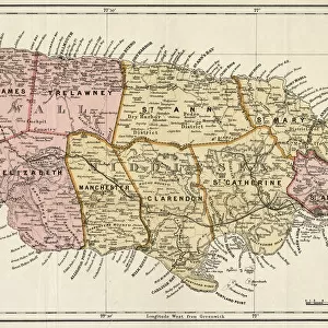
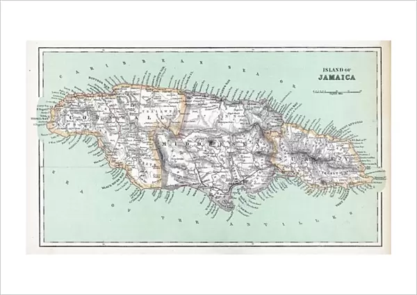
This stunning print of "Maps / Jamaica" from Mary Evans Picture Library transports us back to the 19th century, offering a glimpse into the historical cartography of this beautiful Caribbean island. The intricate details and vibrant colors of this map capture the essence of Jamaica in a way that is both educational and visually captivating.
As we study this mid-19th-century map, we are reminded of Jamaica's rich history and its importance in the West Indies. The careful craftsmanship and attention to detail in this piece speak to the skill and dedication of those who created it, providing us with a valuable insight into how maps were produced during this time period.
From its lush landscapes to its bustling cities, every corner of Jamaica is meticulously depicted on this map, allowing us to explore the island's geography and topography with ease. Whether you are a history buff or simply appreciate fine artistry, this print is sure to spark your curiosity and imagination.
So take a moment to immerse yourself in the past with "Maps / Jamaica" from Mary Evans Prints Online. Let its beauty inspire you to learn more about this fascinating island nation and all that it has to offer.
MADE IN THE USA
Safe Shipping with 30 Day Money Back Guarantee
FREE PERSONALISATION*
We are proud to offer a range of customisation features including Personalised Captions, Color Filters and Picture Zoom Tools
SECURE PAYMENTS
We happily accept a wide range of payment options so you can pay for the things you need in the way that is most convenient for you
* Options may vary by product and licensing agreement. Zoomed Pictures can be adjusted in the Cart.