Fine Art Print > Maps and Charts > World
Fine Art Print : Overton World Map / 1670


![]()
Fine Art Prints from Mary Evans Picture Library
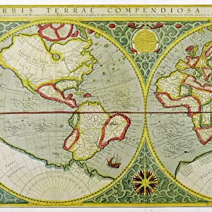
Overton World Map / 1670
A new and accurate map of the world drawn according to the best and late discoveries of 1670
Mary Evans Picture Library makes available wonderful images created for people to enjoy over the centuries
Media ID 592680
© Mary Evans Picture Library 2015 - https://copyrighthub.org/s0/hub1/creation/maryevans/MaryEvansPictureID/10041717
1670 Accurate Best Discoveries Drawn Maps Overton
20"x16" (+3" Border) Fine Art Print
Discover the wonders of the past with our exquisite selection of Fine Art Prints from Media Storehouse, featuring the Overton World Map from 1670. This captivating map, sourced from the esteemed Mary Evans Picture Library, offers a glimpse into the world as it was known over three centuries ago. Meticulously drawn according to the latest discoveries of 1670, this map is a testament to the spirit of exploration and the ever-evolving understanding of our planet. Bring history to life in your home or office with this stunning and intricately detailed work of cartography.
20x16 image printed on 26x22 Fine Art Rag Paper with 3" (76mm) white border. Our Fine Art Prints are printed on 300gsm 100% acid free, PH neutral paper with archival properties. This printing method is used by museums and art collections to exhibit photographs and art reproductions.
Our fine art prints are high-quality prints made using a paper called Photo Rag. This 100% cotton rag fibre paper is known for its exceptional image sharpness, rich colors, and high level of detail, making it a popular choice for professional photographers and artists. Photo rag paper is our clear recommendation for a fine art paper print. If you can afford to spend more on a higher quality paper, then Photo Rag is our clear recommendation for a fine art paper print.
Estimated Image Size (if not cropped) is 50.8cm x 40.6cm (20" x 16")
Estimated Product Size is 66cm x 55.9cm (26" x 22")
These are individually made so all sizes are approximate
Artwork printed orientated as per the preview above, with landscape (horizontal) orientation to match the source image.
FEATURES IN THESE COLLECTIONS
> Maps and Charts
> Early Maps
> Maps and Charts
> Related Images
> Maps and Charts
> World
> Mary Evans Prints Online
> Maps
EDITORS COMMENTS
This stunning print of the Overton World Map from 1670 offers a fascinating glimpse into the historical cartography of the late 17th century. Drawn according to the best and latest discoveries of its time, this map provides an accurate representation of how people viewed the world over 350 years ago.
The intricate details and careful craftsmanship that went into creating this map are truly remarkable, showcasing both the artistry and scientific knowledge of early mapmakers. From coastlines to continents, every feature is meticulously drawn with precision and care.
As we study this map, we can't help but marvel at how much our understanding of geography has evolved since then. The boundaries may have shifted, new lands may have been discovered, but this snapshot in time remains a valuable piece of history that allows us to appreciate how far we've come.
Whether you're a history buff, a lover of maps, or simply someone who appreciates beautiful artwork, this print is sure to captivate your imagination and spark your curiosity about the world as it was seen centuries ago. It's a reminder that even as technology advances and our knowledge grows, there will always be something magical about holding a piece of history in your hands.
MADE IN THE USA
Safe Shipping with 30 Day Money Back Guarantee
FREE PERSONALISATION*
We are proud to offer a range of customisation features including Personalised Captions, Color Filters and Picture Zoom Tools
SECURE PAYMENTS
We happily accept a wide range of payment options so you can pay for the things you need in the way that is most convenient for you
* Options may vary by product and licensing agreement. Zoomed Pictures can be adjusted in the Cart.