Fine Art Print > Europe > France > Canton > Allier
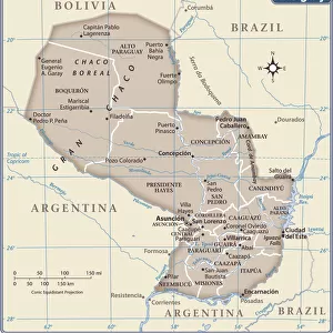
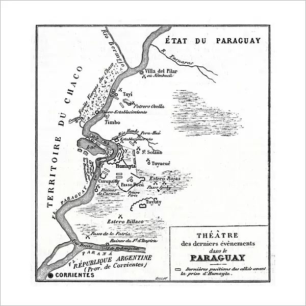
Fine Art Print : Map of the Paraguayan War 1868

![]()
Fine Art Prints from Mary Evans Picture Library
Map of the Paraguayan War 1868
A map of allies positions along the Parana river, up until the capture of Humayta. Date: 1868
Mary Evans Picture Library makes available wonderful images created for people to enjoy over the centuries
Media ID 23089312
© Mary Evans Picture Library
1868 Alliance Allies Argentine Battles Capture Movements Paraguay Paraguayan Parana Positions Triple
20"x20" (+3" Border) Fine Art Print
Discover the rich history of the Paraguayan War with our exquisite Fine Art Print from Media Storehouse, featuring a detailed map of the conflict's key battles. Dated 1868, this captivating image from Mary Evans Prints Online illustrates the strategic positions of the allied forces along the Parana River, leading up to the capture of Humaita. Add this stunning piece to your collection and bring the history of the Paraguayan War into your home or office.
20x20 image printed on 26x26 Fine Art Rag Paper with 3" (76mm) white border. Our Fine Art Prints are printed on 300gsm 100% acid free, PH neutral paper with archival properties. This printing method is used by museums and art collections to exhibit photographs and art reproductions.
Our fine art prints are high-quality prints made using a paper called Photo Rag. This 100% cotton rag fibre paper is known for its exceptional image sharpness, rich colors, and high level of detail, making it a popular choice for professional photographers and artists. Photo rag paper is our clear recommendation for a fine art paper print. If you can afford to spend more on a higher quality paper, then Photo Rag is our clear recommendation for a fine art paper print.
Estimated Image Size (if not cropped) is 46.7cm x 50.8cm (18.4" x 20")
Estimated Product Size is 66cm x 66cm (26" x 26")
These are individually made so all sizes are approximate
Artwork printed orientated as per the preview above, with portrait (vertical) orientation to match the source image.
FEATURES IN THESE COLLECTIONS
> Arts
> Art Movements
> Related Images
> Arts
> Landscape paintings
> Waterfall and river artworks
> River artworks
> Europe
> France
> Canton
> Allier
> Historic
> Battles
> Related Images
> Maps and Charts
> Related Images
> South America
> Argentina
> Maps
> South America
> Argentina
> Parana
> South America
> Argentina
> Related Images
> South America
> Paraguay
> Maps
> South America
> Paraguay
> Related Images
> Mary Evans Prints Online
> New Images August 2021
EDITORS COMMENTS
This historic map print, dated 1868, provides a detailed view of the strategic positions of the allied forces during the pivotal moments of the Paraguayan War. The map focuses on the area along the Parana River, highlighting the positions of the Argentine Republic, the Brazilian Empire, and the Uruguayan State, who formed the Triple Alliance to challenge the military rule of Paraguay under the command of Marshal Francisco Solano Lopez. The map illustrates the intricate movements and battles that took place during this protracted conflict, which lasted from 1864 to 1870. The allied forces, seeking to weaken Paraguay's military might, launched a series of offensives along the Parana River, culminating in the capture of the crucial stronghold of Humaita in 1868. The fortress, located on an island in the Parana River, had been a major obstacle for the allied forces, as it controlled access to the river and allowed Paraguay to launch devastating counter-attacks. The map offers valuable insights into the military strategies employed by the allied forces during the Paraguayan War. The intricate details of the map, including the locations of key battle sites, camps, and fortifications, provide a tangible connection to this significant period in South American history. The map is a testament to the complex geopolitical landscape of the region during the late 19th century and the determination of the Triple Alliance to bring an end to Paraguay's military rule. This map print is a valuable addition to any collection of historical maps or South American studies, offering a unique perspective on the military campaigns and strategic maneuvers that shaped the outcome of the Paraguayan War. The intricate details and historical significance make it a must-have for scholars, educators, and history enthusiasts alike.
MADE IN THE USA
Safe Shipping with 30 Day Money Back Guarantee
FREE PERSONALISATION*
We are proud to offer a range of customisation features including Personalised Captions, Color Filters and Picture Zoom Tools
SECURE PAYMENTS
We happily accept a wide range of payment options so you can pay for the things you need in the way that is most convenient for you
* Options may vary by product and licensing agreement. Zoomed Pictures can be adjusted in the Cart.