Fine Art Print > Europe > France > Canton > Landes
Fine Art Print : METROLAND MAP


![]()
Fine Art Prints from Mary Evans Picture Library
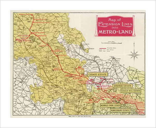
METROLAND MAP
A map of Metro-Land, the residential area in Londons northwest hinterland, served by Londons Underground though in these parts most of it runs over ground. Date: 1926
Mary Evans Picture Library makes available wonderful images created for people to enjoy over the centuries
Media ID 23032692
© Mary Evans Picture Library
Area Communities Community Londons Metro Northwest Parts Planning Residential Runs Served Towns Underground 1926 Hinterland
20"x16" (+3" Border) Fine Art Print
Discover the rich history of London's Metroland with our stunning Fine Art Print of the Metroland Map by Rights Managed from Mary Evans Prints Online. This vintage print, dating back to 1926, showcases the Metroland residential area in the northwest hinterland of London, where much of the Underground network runs above ground. Add an elegant touch to your home or office decor with this beautifully detailed and historically significant print. Perfect for transport enthusiasts, history buffs, or anyone who appreciates the charm of old maps. Order now and step back in time with Media Storehouse's range of Fine Art Prints.
20x16 image printed on 26x22 Fine Art Rag Paper with 3" (76mm) white border. Our Fine Art Prints are printed on 300gsm 100% acid free, PH neutral paper with archival properties. This printing method is used by museums and art collections to exhibit photographs and art reproductions.
Our fine art prints are high-quality prints made using a paper called Photo Rag. This 100% cotton rag fibre paper is known for its exceptional image sharpness, rich colors, and high level of detail, making it a popular choice for professional photographers and artists. Photo rag paper is our clear recommendation for a fine art paper print. If you can afford to spend more on a higher quality paper, then Photo Rag is our clear recommendation for a fine art paper print.
Estimated Image Size (if not cropped) is 50.8cm x 40.6cm (20" x 16")
Estimated Product Size is 66cm x 55.9cm (26" x 22")
These are individually made so all sizes are approximate
Artwork printed orientated as per the preview above, with landscape (horizontal) orientation to match the source image.
FEATURES IN THESE COLLECTIONS
> Europe
> France
> Canton
> Landes
> Europe
> United Kingdom
> England
> London
> Related Images
> Maps and Charts
> Early Maps
> Maps and Charts
> Related Images
> Mary Evans Prints Online
> New Images August 2021
MADE IN THE USA
Safe Shipping with 30 Day Money Back Guarantee
FREE PERSONALISATION*
We are proud to offer a range of customisation features including Personalised Captions, Color Filters and Picture Zoom Tools
SECURE PAYMENTS
We happily accept a wide range of payment options so you can pay for the things you need in the way that is most convenient for you
* Options may vary by product and licensing agreement. Zoomed Pictures can be adjusted in the Cart.