Fine Art Print > Europe > United Kingdom > England > Yorkshire > Pontefract
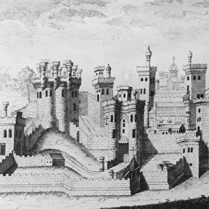
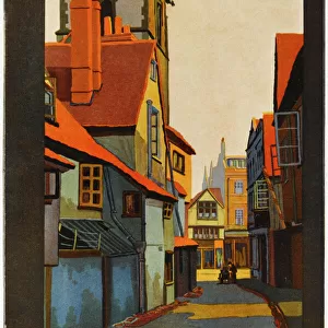
Fine Art Print : PONTEFRACT CASTLE, Yorkshire


Fine Art Prints from Mary Evans Picture Library
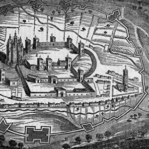
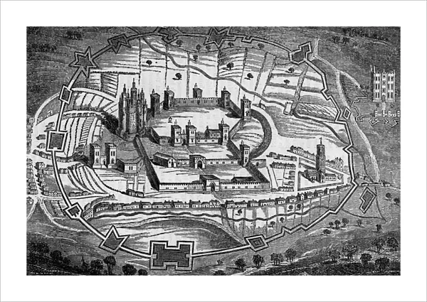
PONTEFRACT CASTLE, Yorkshire
Bird s-eye view of Pontefract Castle, Yorkshire, as it appeared during the Civil War. Date: 1648
Mary Evans Picture Library makes available wonderful images created for people to enjoy over the centuries
Media ID 7215549
© Mary Evans Picture Library 2015 - https://copyrighthub.org/s0/hub1/creation/maryevans/MaryEvansPictureID/10238298
21"x14" (+3" Border) Fine Art Print
Experience the rich history of Pontefract Castle in Yorkshire with our exquisite Fine Art Print from Media Storehouse. This stunning bird's-eye view, taken from Mary Evans Prints Online during the Civil War in 1648, transports you back in time. Add a touch of history and elegance to your home or office with this beautifully detailed and authentic print. Rights Managed through Media Storehouse ensures the highest quality and authenticity. Order now and let this timeless piece be the conversation starter in your space.
21x14 image printed on 27x20 Fine Art Rag Paper with 3" (76mm) white border. Our Fine Art Prints are printed on 300gsm 100% acid free, PH neutral paper with archival properties. This printing method is used by museums and art collections to exhibit photographs and art reproductions.
Our fine art prints are high-quality prints made using a paper called Photo Rag. This 100% cotton rag fibre paper is known for its exceptional image sharpness, rich colors, and high level of detail, making it a popular choice for professional photographers and artists. Photo rag paper is our clear recommendation for a fine art paper print. If you can afford to spend more on a higher quality paper, then Photo Rag is our clear recommendation for a fine art paper print.
Estimated Image Size (if not cropped) is 53.3cm x 35.5cm (21" x 14")
Estimated Product Size is 68.6cm x 50.8cm (27" x 20")
These are individually made so all sizes are approximate
Artwork printed orientated as per the preview above, with landscape (horizontal) orientation to match the source image.
FEATURES IN THESE COLLECTIONS
> Aerial Photography
> England
> Aerial Photography
> Related Images
> Europe
> United Kingdom
> England
> Aerial Views
> Europe
> United Kingdom
> England
> Castles
> Europe
> United Kingdom
> England
> Maps
> Europe
> United Kingdom
> England
> Posters
> Europe
> United Kingdom
> England
> Related Images
> Europe
> United Kingdom
> England
> Yorkshire
> Pontefract
> Europe
> United Kingdom
> England
> Yorkshire
> Related Images
> Maps and Charts
> Related Images
MADE IN THE USA
Safe Shipping with 30 Day Money Back Guarantee
FREE PERSONALISATION*
We are proud to offer a range of customisation features including Personalised Captions, Color Filters and Picture Zoom Tools
SECURE PAYMENTS
We happily accept a wide range of payment options so you can pay for the things you need in the way that is most convenient for you
* Options may vary by product and licensing agreement. Zoomed Pictures can be adjusted in the Cart.