Fine Art Print : Proposed extensions of transport links into London 1919


![]()
Fine Art Prints from Mary Evans Picture Library
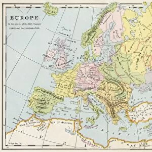
Proposed extensions of transport links into London 1919
Diagram showing a map of London and the movement of commuters by different travel means from Greater to Central London, and the proposed extensions of transport links and increase of capacity of buses and vehicles.
1919
Mary Evans Picture Library makes available wonderful images created for people to enjoy over the centuries
Media ID 14387508
© Mary Evans Picture Library
Commute Commuters Commuting Diagram Double Extension Greater Hour Hours Improve Improvement Improvements Improving Journey Maps Mar16 Ministry Network Outer Passengers Plan Plans Population Proposals Railways Route Routes Rush Spread Traffic Trains Travelling Tube Tubes Underground Vehicles 1919
20"x16" (+3" Border) Fine Art Print
Discover the captivating history of London's transportation evolution with our Fine Art Print of "Proposed extensions of transport links into London 1919" by Mary Evans Picture Library from Mary Evans Prints Online. This exquisite print showcases a detailed diagram of London, illustrating the movement of commuters from Greater to Central London via various transport means. Delve into the past as you admire the proposed extensions of transport links, adding a touch of historical intrigue to your home or office space. Bring the rich history of London's transportation system into your world with this stunning Fine Art Print.
20x16 image printed on 26x22 Fine Art Rag Paper with 3" (76mm) white border. Our Fine Art Prints are printed on 300gsm 100% acid free, PH neutral paper with archival properties. This printing method is used by museums and art collections to exhibit photographs and art reproductions.
Our fine art prints are high-quality prints made using a paper called Photo Rag. This 100% cotton rag fibre paper is known for its exceptional image sharpness, rich colors, and high level of detail, making it a popular choice for professional photographers and artists. Photo rag paper is our clear recommendation for a fine art paper print. If you can afford to spend more on a higher quality paper, then Photo Rag is our clear recommendation for a fine art paper print.
Estimated Image Size (if not cropped) is 50.8cm x 35.3cm (20" x 13.9")
Estimated Product Size is 66cm x 55.9cm (26" x 22")
These are individually made so all sizes are approximate
Artwork printed orientated as per the preview above, with landscape (horizontal) orientation to match the source image.
EDITORS COMMENTS
1919: Proposed Extensions of Transport Links into London - A Diagram of Transportation in Greater and Central London and the Commuting Routes of Passengers This diagram from 1919 offers a unique insight into the transportation network of London during a pivotal moment in its history. The map, produced by the Ministry of Transport, illustrates the movement of commuters from the outer boroughs to Central London using various transport modes, including buses, vehicles, trains, and the underground. The intricate lines and color-coded key represent the proposed extensions and improvements to transport links, aimed at increasing capacity and accommodating the growing population and workforce. The diagram reveals the extensive commuting routes from the south, east, and west, with passengers traveling to Central London during the rush hours. The existing railway lines crisscross the city, while the proposed extensions, such as the Northern Heights Extension and the extension of the Piccadilly line, are indicated by dotted lines. The underground network, represented by the tubes, is shown expanding with new lines and stations. The diagram also highlights the importance of buses and vehicles in the transportation system, with proposed improvements to their capacity and routes. The double-page spread offers a comprehensive view of the transport infrastructure, demonstrating the Ministry's commitment to improving the transportation network and accommodating the needs of the expanding city. This fascinating diagram serves as a testament to the ingenuity and vision of the transportation planners of the time, who anticipated the demands of a growing population and worked tirelessly to ensure that London remained a connected and accessible city.
MADE IN THE USA
Safe Shipping with 30 Day Money Back Guarantee
FREE PERSONALISATION*
We are proud to offer a range of customisation features including Personalised Captions, Color Filters and Picture Zoom Tools
SECURE PAYMENTS
We happily accept a wide range of payment options so you can pay for the things you need in the way that is most convenient for you
* Options may vary by product and licensing agreement. Zoomed Pictures can be adjusted in the Cart.