Fine Art Print > Europe > Russia > Maps
Fine Art Print : Russia / Moscow / Map / C16


![]()
Fine Art Prints from Mary Evans Picture Library
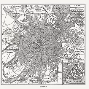
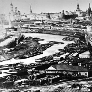
Russia / Moscow / Map / C16
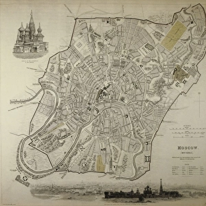
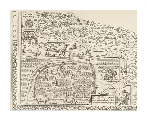
General map of Moscow
Mary Evans Picture Library makes available wonderful images created for people to enjoy over the centuries
Media ID 584163
© Mary Evans Picture Library 2015 - https://copyrighthub.org/s0/hub1/creation/maryevans/MaryEvansPictureID/10035668
20"x16" (+3" Border) Fine Art Print
Discover the rich history and culture of Russia with our exquisite selection of Fine Art Prints from Mary Evans Picture Library. This captivating image, titled "Moscow - Map of the City in the Time of Catherine II (C16)", transports you back to the 18th century as you explore the layout of Moscow during the reign of Catherine the Great. The intricate details of the map reveal the grandeur and complexity of the city, making it a stunning addition to any home or office. Bring a piece of Russian history into your space with this beautifully detailed and authentic print from our Media Storehouse range of Fine Art Prints.
20x16 image printed on 26x22 Fine Art Rag Paper with 3" (76mm) white border. Our Fine Art Prints are printed on 300gsm 100% acid free, PH neutral paper with archival properties. This printing method is used by museums and art collections to exhibit photographs and art reproductions.
Our fine art prints are high-quality prints made using a paper called Photo Rag. This 100% cotton rag fibre paper is known for its exceptional image sharpness, rich colors, and high level of detail, making it a popular choice for professional photographers and artists. Photo rag paper is our clear recommendation for a fine art paper print. If you can afford to spend more on a higher quality paper, then Photo Rag is our clear recommendation for a fine art paper print.
Estimated Image Size (if not cropped) is 50.8cm x 40.6cm (20" x 16")
Estimated Product Size is 66cm x 55.9cm (26" x 22")
These are individually made so all sizes are approximate
Artwork printed orientated as per the preview above, with landscape (horizontal) orientation to match the source image.
FEATURES IN THESE COLLECTIONS
> Europe
> Russia
> Related Images
> Maps and Charts
> Early Maps
> Maps and Charts
> Related Images
EDITORS COMMENTS
This stunning print captures a piece of history with a general map of Moscow from the 16th century. The intricate details and craftsmanship of this historical map provide a glimpse into what the city looked like during that time period. From the winding streets to the iconic landmarks, every aspect of Moscow is beautifully depicted in this image.
Dating back to around 1590, this map offers a unique perspective on the layout and structure of one of Russia's most famous cities. It serves as a valuable resource for historians and enthusiasts alike who are interested in exploring the rich history and culture of Moscow.
The artistic flair and attention to detail in this map showcase the skill and dedication that went into creating such an important piece of cartography. Each line, symbol, and label tells a story about the city's past, making it not just a geographical representation but also a historical artifact.
Whether you have an interest in maps, history, or simply appreciate beautiful artwork, this print is sure to captivate your imagination. It serves as a reminder of how far we've come while also honoring the legacy and heritage of Moscow through centuries gone by.
MADE IN THE USA
Safe Shipping with 30 Day Money Back Guarantee
FREE PERSONALISATION*
We are proud to offer a range of customisation features including Personalised Captions, Color Filters and Picture Zoom Tools
SECURE PAYMENTS
We happily accept a wide range of payment options so you can pay for the things you need in the way that is most convenient for you
* Options may vary by product and licensing agreement. Zoomed Pictures can be adjusted in the Cart.