Fine Art Print > Arts > Artists > M > Gerardus Mercator
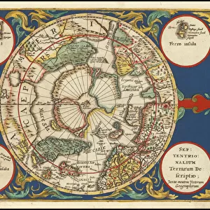
Fine Art Print : Septentrionalium Terrarum descriptio, 1595, by Gerardus Merc

![]()
Fine Art Prints from Mary Evans Picture Library
Septentrionalium Terrarum descriptio, 1595, by Gerardus Merc
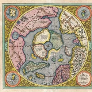
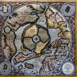
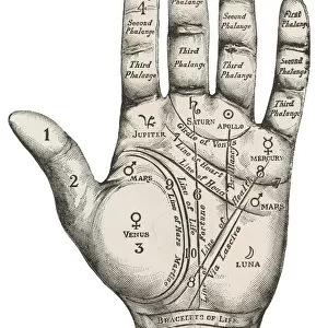
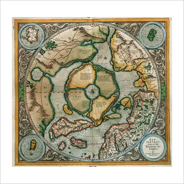
Gerardus Mercator (1512-1594). Flemish cartographer. Septentrionalium Terrarum descriptio. Map of the Arctic with the North Pole and surrounding lands within and outside the Arctic Circle, 1595
Mary Evans Picture Library makes available wonderful images created for people to enjoy over the centuries
Media ID 14330268
© Thaliastock / Mary Evans
1595 Arctic Area Carthography Cartographer Cartography Circle Descriptio Earth Flanders Flemish Gerard Gerardus Globe Kremer Latin Letter Letters Mathematician Mercator Netherlands Philosopher Philosophy Pole Surrounding Terrarum Terrestrial
20"x20" (+3" Border) Fine Art Print
Discover the captivating world of exploration and cartography with our Fine Art Prints from Media Storehouse. This exquisite piece showcases the Septentrionalium Terrarum descriptio, a masterpiece by the renowned Flemish cartographer Gerardus Mercator from 1595. Depicting the Arctic with intricate detail, this map features the North Pole and the lands within and outside the Arctic Circle. A stunning addition to any home or office, this Rights Managed print from Mary Evans Prints Online brings history and artistry together in perfect harmony.
20x20 image printed on 26x26 Fine Art Rag Paper with 3" (76mm) white border. Our Fine Art Prints are printed on 300gsm 100% acid free, PH neutral paper with archival properties. This printing method is used by museums and art collections to exhibit photographs and art reproductions.
Our fine art prints are high-quality prints made using a paper called Photo Rag. This 100% cotton rag fibre paper is known for its exceptional image sharpness, rich colors, and high level of detail, making it a popular choice for professional photographers and artists. Photo rag paper is our clear recommendation for a fine art paper print. If you can afford to spend more on a higher quality paper, then Photo Rag is our clear recommendation for a fine art paper print.
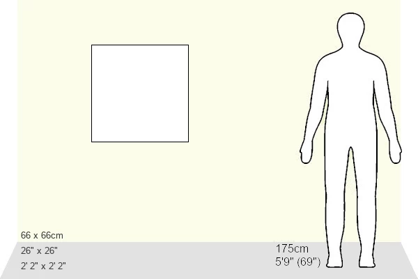
Estimated Image Size (if not cropped) is 50.8cm x 47.5cm (20" x 18.7")
Estimated Product Size is 66cm x 66cm (26" x 26")
These are individually made so all sizes are approximate
Artwork printed orientated as per the preview above, with landscape (horizontal) orientation to match the source image.
FEATURES IN THESE COLLECTIONS
> Arts
> Artists
> M
> Gerardus Mercator
> Europe
> France
> Canton
> Landes
> Europe
> Netherlands
> Maps
> Europe
> Netherlands
> Posters
> Europe
> Netherlands
> Related Images
> Europe
> Related Images
> Maps and Charts
> Early Maps
> Maps and Charts
> Gerardus Mercator's Cartographic
> Maps and Charts
> Netherlands
> Maps and Charts
> Related Images
Septentrionalium Terrarum Descriptio,
EDITORS COMMENTS
a captivating masterpiece created by the renowned Flemish cartographer Gerardus Mercator in 1595, offers a glimpse into the intriguing world of Arctic exploration during the late 16th century. This meticulously crafted map, also known as "Description of the Northern Lands," provides a detailed representation of the Arctic region and the lands situated within and beyond the Arctic Circle. Mercator, a mathematician, philosopher, and cartographer, was a pioneer in the modern age of cartography. His expertise in mapmaking was unparalleled, and his works significantly advanced the understanding of the terrestrial world during the European Renaissance. This engraving, produced in Flanders, showcases Mercator's unwavering dedication to accurate geographical representation. The map's central focus is the Arctic Circle, with the North Pole at its heart. The intricate detailing of the surrounding seas, including the Greenland Sea, the Norwegian Sea, and the Arctic Ocean, reveals the extensive knowledge Mercator had acquired through various sources, such as explorers' accounts and previous maps. The map also features the lettered labels identifying various lands, islands, and waterways, providing valuable context for the viewer. Septentrionalium Terrarum Descriptio serves as a testament to Mercator's unwavering curiosity and commitment to expanding human knowledge of the world. This map not only represents a significant contribution to the history of cartography but also offers a fascinating glimpse into the European exploration of the Arctic during the late 16th century.
MADE IN THE USA
Safe Shipping with 30 Day Money Back Guarantee
FREE PERSONALISATION*
We are proud to offer a range of customisation features including Personalised Captions, Color Filters and Picture Zoom Tools
SECURE PAYMENTS
We happily accept a wide range of payment options so you can pay for the things you need in the way that is most convenient for you
* Options may vary by product and licensing agreement. Zoomed Pictures can be adjusted in the Cart.