Fine Art Print > Europe > Spain > Related Images
Fine Art Print : Spain. Catalonia. Barcelona. Map, 1576 at Civitates


![]()
Fine Art Prints from Mary Evans Picture Library
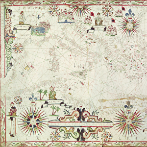
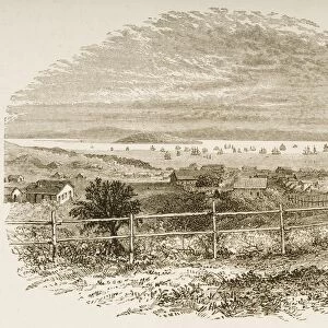
Spain. Catalonia. Barcelona. Map, 1576 at Civitates
Spain. Catalonia. Barcelona. Map, 1576 at Civitates Orbis Terrarum by Georg Braun (1541-1622) and Franz Hogenberg (1536-1590). Salamanca University Library
Mary Evans Picture Library makes available wonderful images created for people to enjoy over the centuries
Media ID 14404650
© Thaliastock / Mary Evans
1576 Agriculture Barcelona Cartography Catalan Catalonia Civitates Crop Farmer Hogenberg Mediterranean Orbis Plough Terrarum
20"x20" (+3" Border) Fine Art Print
Discover the rich history and culture of Barcelona and Catalonia with this exquisite fine art print from Media Storehouse. Dating back to 1576, this rare map, titled 'Catalonia. Barcelona' is taken from the renowned Civitates Orbis Terrarum by Georg Braun and Franz Hogenberg. This intricately detailed map, featuring the vibrant city of Barcelona and the surrounding Catalonia region, offers a unique glimpse into the past. Meticulously reproduced from the original map held at the Salamanca University Library, this fine art print makes a stunning addition to any home or office, transporting you back in time and inviting you to explore the wonders of Spain's rich heritage.
21x7 image printed on 27x13 Fine Art Rag Paper with 3" (76mm) white border. Our Fine Art Prints are printed on 300gsm 100% acid free, PH neutral paper with archival properties. This printing method is used by museums and art collections to exhibit photographs and art reproductions.
Our fine art prints are high-quality prints made using a paper called Photo Rag. This 100% cotton rag fibre paper is known for its exceptional image sharpness, rich colors, and high level of detail, making it a popular choice for professional photographers and artists. Photo rag paper is our clear recommendation for a fine art paper print. If you can afford to spend more on a higher quality paper, then Photo Rag is our clear recommendation for a fine art paper print.
Estimated Image Size (if not cropped) is 51cm x 17.7cm (20.1" x 7")
Estimated Product Size is 68.6cm x 33cm (27" x 13")
These are individually made so all sizes are approximate
Artwork printed orientated as per the preview above, with landscape (horizontal) orientation to match the source image.
EDITORS COMMENTS
This map print, titled "Catalonia. Barcelona" from the atlas "Civitates Orbis Terrarum," was created by the renowned cartographers Georg Braun and Franz Hogenberg in 1576. The map provides a fascinating glimpse into the Mediterranean landscape of Catalonia, with a particular focus on the vibrant city of Barcelona during the late 16th century. The map is adorned with intricate details, showcasing the topography, cities, and towns of the region. The rolling hills and verdant fields are depicted in rich greens and browns, with the sparkling Mediterranean Sea in the foreground. The map reveals the extensive agricultural activities of the time, with farmers working the land and tending to their crops, which include grains, olives, and vineyards. The map also highlights the urban landscape of Barcelona, with its winding streets, fortifications, and prominent buildings. The Pla de Palau, the Gothic Quarter, and the harbor are all clearly visible, providing a snapshot of the city's layout and importance as a major port during the Modern Age. The map, which is part of the extensive collection at the Salamanca University Library, is a testament to the meticulous cartographic skills of Braun and Hogenberg during the Age of Discovery. The rich colors, intricate details, and historical significance make this map a valuable resource for scholars, historians, and anyone interested in the history of Catalonia and Barcelona during the 16th century.
MADE IN THE USA
Safe Shipping with 30 Day Money Back Guarantee
FREE PERSONALISATION*
We are proud to offer a range of customisation features including Personalised Captions, Color Filters and Picture Zoom Tools
SECURE PAYMENTS
We happily accept a wide range of payment options so you can pay for the things you need in the way that is most convenient for you
* Options may vary by product and licensing agreement. Zoomed Pictures can be adjusted in the Cart.