Fine Art Print > Asia > Lebanon > Maps
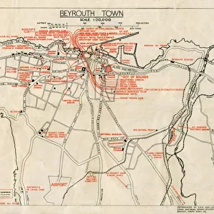
Fine Art Print : WW2 - Map of Beirut, Lebanon - with Military locations


![]()
Fine Art Prints from Mary Evans Picture Library
WW2 - Map of Beirut, Lebanon - with Military locations
End of WW2 - Map of Beirut, Lebanon showing Military locations important for a British serviceman stationed in the city at the end of the Second World War. The reverse of the map lists the Dos and Don ts whilst on leave in the city! Date: 1945
Mary Evans Picture Library makes available wonderful images created for people to enjoy over the centuries
Media ID 14391078
© Mary Evans / Pharcide
1945 Airport Beirut Beyrouth Chart Cinema Clubs Hostel Lebanese Lebanon Locations Plan
20"x16" (+3" Border) Fine Art Print
Step back in time with our exclusive Fine Art Print from Media Storehouse, featuring a captivating map of Beirut, Lebanon during the end of World War II. This intricately detailed map, sourced from Mary Evans Prints Online, highlights the military locations that were pivotal for a British serviceman stationed in the city. Add an authentic touch to your home or office decor, and transport yourself back to a bygone era with this stunning piece of historical art.
20x16 image printed on 26x22 Fine Art Rag Paper with 3" (76mm) white border. Our Fine Art Prints are printed on 300gsm 100% acid free, PH neutral paper with archival properties. This printing method is used by museums and art collections to exhibit photographs and art reproductions.
Our fine art prints are high-quality prints made using a paper called Photo Rag. This 100% cotton rag fibre paper is known for its exceptional image sharpness, rich colors, and high level of detail, making it a popular choice for professional photographers and artists. Photo rag paper is our clear recommendation for a fine art paper print. If you can afford to spend more on a higher quality paper, then Photo Rag is our clear recommendation for a fine art paper print.
Estimated Image Size (if not cropped) is 50.4cm x 40.6cm (19.8" x 16")
Estimated Product Size is 66cm x 55.9cm (26" x 22")
These are individually made so all sizes are approximate
Artwork printed orientated as per the preview above, with landscape (horizontal) orientation to match the source image.
FEATURES IN THESE COLLECTIONS
> Asia
> Lebanon
> Related Images
> Historic
> World War I and II
> World War II
> Maps and Charts
> Related Images
> Maps and Charts
> World
EDITORS COMMENTS
This vintage map of Beirut, Lebanon, dates back to the end of World War II in 1945. The map provides an intriguing glimpse into the city as it appeared during that historical period, with a specific focus on military locations that would have been of particular importance to a British serviceman stationed in the area. The map is rich in detail, highlighting various military installations, barracks, and camps scattered throughout the city. These included the British Military Headquarters located near the Martyrs' Square, the Royal Army Ordnance Corps Depot in Ras Beirut, and the Royal Navy Base at the Beirut Waterfront. On the reverse side of the map, a list of "Dos and Don'ts" is provided for the serviceman on his leave in the city. The "Dos" include recommendations to visit popular clubs and cinemas such as the American Club, the British Club, and the Riviera Cinema. The "Don'ts," on the other hand, caution against visiting certain areas of the city, particularly those with a high crime rate or known to be off-limits to Allied personnel. The map also includes various other points of interest, such as hotels, hostels, and the Beirut International Airport. The Lebanese capital was a bustling hub of activity during the post-war period, and this map offers a fascinating insight into the city's military and social landscape at that time. This map is a valuable historical document, providing a unique perspective on Beirut during the waning days of World War II and the early days of the peace that followed. It is a reminder of the rich history and cultural diversity of this fascinating city and the role it played in world events during that era.
MADE IN THE USA
Safe Shipping with 30 Day Money Back Guarantee
FREE PERSONALISATION*
We are proud to offer a range of customisation features including Personalised Captions, Color Filters and Picture Zoom Tools
SECURE PAYMENTS
We happily accept a wide range of payment options so you can pay for the things you need in the way that is most convenient for you
* Options may vary by product and licensing agreement. Zoomed Pictures can be adjusted in the Cart.