Fine Art Print > North America > United States of America > Virginia > Alexandria
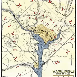
Fine Art Print : Washington DC during the Civil War

![]()
Fine Art Prints from North Wind
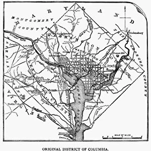
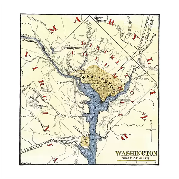
Washington DC during the Civil War
Map of the Washington DC vicinity at the outset of the Civil War.
Hand-colored woodcut of a 19th century-illustration
North Wind Picture Archives brings history to life with stock images and hand-colored illustrations
Media ID 5879756
© North Wind Picture Archives
1860s Alexandria America Potomac River Virginia Washington Dc
20"x20" (+3" Border) Fine Art Print
Step back in time with Media Storehouse's exquisite Fine Art Prints from North Wind Picture Archives. This captivating image transports you to the heart of Washington D.C. during the tumultuous era of the American Civil War. Hand-colored woodcut illustrations bring to life the intricate details of the historic map, offering a unique perspective on the city's layout at the outset of the conflict. Add this stunning piece to your collection and let the history unfold before your eyes.
20x20 image printed on 26x26 Fine Art Rag Paper with 3" (76mm) white border. Our Fine Art Prints are printed on 300gsm 100% acid free, PH neutral paper with archival properties. This printing method is used by museums and art collections to exhibit photographs and art reproductions.
Our fine art prints are high-quality prints made using a paper called Photo Rag. This 100% cotton rag fibre paper is known for its exceptional image sharpness, rich colors, and high level of detail, making it a popular choice for professional photographers and artists. Photo rag paper is our clear recommendation for a fine art paper print. If you can afford to spend more on a higher quality paper, then Photo Rag is our clear recommendation for a fine art paper print.
Estimated Image Size (if not cropped) is 47.2cm x 50.8cm (18.6" x 20")
Estimated Product Size is 66cm x 66cm (26" x 26")
These are individually made so all sizes are approximate
Artwork printed orientated as per the preview above, with portrait (vertical) orientation to match the source image.
FEATURES IN THESE COLLECTIONS
> Arts
> Landscape paintings
> Waterfall and river artworks
> River artworks
> North America
> Related Images
> North America
> United States of America
> Virginia
> Alexandria
> North Wind Picture Archives
> Civil War (US)
> North Wind Picture Archives
> Maps
EDITORS COMMENTS
This print takes us back in time to the tumultuous era of the American Civil War. The hand-colored woodcut, created in the 19th century, showcases a map of Washington DC and its vicinity at the outset of this historic conflict. With its vintage charm and intricate details, this illustration offers a glimpse into the rich heritage and traditional artistry of that era. The map depicts an aerial view of Washington DC, nestled along the banks of the Potomac River. It highlights key landmarks such as Alexandria in Virginia, which played a significant role during this period. As we study this piece closely, we can almost feel ourselves transported to those uncertain times when our nation was divided. Through this image, we are reminded of America's complex history and how it has shaped our present-day society. It serves as a visual testament to the struggles faced by our ancestors and their unwavering determination for freedom and unity. As we admire this remarkable piece from North Wind Picture Archives, let us reflect on how far we have come as a nation since those turbulent days. May it inspire us to cherish our shared values and continue striving towards progress while honoring our past.
MADE IN THE USA
Safe Shipping with 30 Day Money Back Guarantee
FREE PERSONALISATION*
We are proud to offer a range of customisation features including Personalised Captions, Color Filters and Picture Zoom Tools
SECURE PAYMENTS
We happily accept a wide range of payment options so you can pay for the things you need in the way that is most convenient for you
* Options may vary by product and licensing agreement. Zoomed Pictures can be adjusted in the Cart.