Fine Art Print > Arts > Contemporary art > Digital artwork > Technological art
Fine Art Print : Air traffic visualisation


![]()
Fine Art Prints from Science Photo Library
Air traffic visualisation
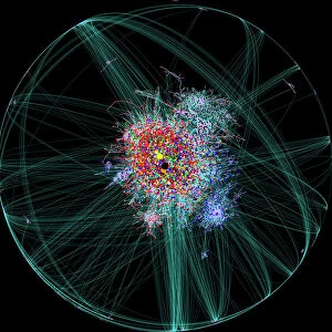
Air traffic visualisation. Computer artwork of air traffic over the USA. This image is one frame from an animation of air traffic over a 24-hour period. Air traffic data from the US Federal Aviation Administration (Fa) was plotted using a programming language called Processing and animated using Adobe After Effects and Maya. Plot colour and size were assigned based on aircraft type, location and altitude. This frame shows flight activity over the east coast of USA (right), west coast (left), central USA (centre), Florida and the Caribbean (lower right). The full animation reveals up to 19, 000 aircraft flying over the USA at any one time. Created by Aaron Koblin, design and media arts researcher, University of California, USA
Science Photo Library features Science and Medical images including photos and illustrations
Media ID 7691865
© AARON KOBLIN/SCIENCE PHOTO LIBRARY
Administration Air Craft Air Traffic Algorithm Animation Aviation Complex Data Complex Network Complex Visualisation Computational Computer Computer Generated Computer Graphics Computer Rendered Connection Connections Connectivity Data Data Visualisation Data Visualization Digital Information Flight Flying Graph Graphic Graphs Infographic Infographics Informatics Net Work North American Processing Transport Transportation Us A Visual Complexity Visualisation Visualization Algorithms Computer Artwork Flights Maya
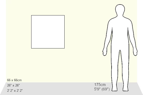
20"x20" (+3" Border) Fine Art Print
Experience the breathtaking spectacle of global connectivity with our Media Storehouse Fine Art Prints featuring this captivating Air Traffic Visualisation by Science Photo Library. This mesmerising computer artwork presents a single frame from an animation of air traffic over the USA, showcasing the intricate patterns and constant movement of aircraft across the country. Each print is meticulously produced using high-quality materials, ensuring vibrant colours and exceptional detail. Bring this stunning representation of modern transportation into your home or office and ignite conversations about the wonders of technology and the interconnectedness of our world.
20x20 image printed on 26x26 Fine Art Rag Paper with 3" (76mm) white border. Our Fine Art Prints are printed on 300gsm 100% acid free, PH neutral paper with archival properties. This printing method is used by museums and art collections to exhibit photographs and art reproductions.
Our fine art prints are high-quality prints made using a paper called Photo Rag. This 100% cotton rag fibre paper is known for its exceptional image sharpness, rich colors, and high level of detail, making it a popular choice for professional photographers and artists. Photo rag paper is our clear recommendation for a fine art paper print. If you can afford to spend more on a higher quality paper, then Photo Rag is our clear recommendation for a fine art paper print.
Estimated Image Size (if not cropped) is 50.8cm x 50.8cm (20" x 20")
Estimated Product Size is 66cm x 66cm (26" x 26")
These are individually made so all sizes are approximate
Artwork printed orientated as per the preview above, with landscape (horizontal) or portrait (vertical) orientation to match the source image.
FEATURES IN THESE COLLECTIONS
> Animals
> Mammals
> Cricetidae
> California Mouse
> Arts
> Contemporary art
> Digital artwork
> Technological art
> Arts
> Street art graffiti
> Digital art
> Digital paintings
> Asia
> East Timor
> Maps
> Asia
> East Timor
> Related Images
> Maps and Charts
> Related Images
> North America
> Related Images
> North America
> United States of America
> California
> Related Images
> North America
> United States of America
> Florida
> Related Images
EDITORS COMMENTS
This print showcases a mesmerizing visualisation of air traffic over the United States. Created by Aaron Koblin, a design and media arts researcher at the University of California, this computer artwork is one frame from an animation that spans a 24-hour period. Using data from the US Federal Aviation Administration (FAA), Koblin plotted the flight paths using Processing, a programming language, and animated them with Adobe After Effects and Maya. The image reveals an intricate network of flights covering different regions of the country. The east coast dominates the right side, while the west coast can be seen on the left. In between lies central USA, with Florida and the Caribbean visible in the lower right corner. Each aircraft's type, location, and altitude are represented through assigned colors and sizes. The full animation exposes an astonishing sight: up to 19,000 aircraft flying simultaneously across America's skies. This complex visualization demonstrates both technological prowess and artistic skill as it brings together elements of computer graphics, algorithms, connectivity analysis, and computational power. By combining digital information with creative flair, this artwork offers viewers a unique perspective on air travel patterns within North America. It serves as a testament to our ability to harness technology for both practical purposes like transportation management as well as aesthetic endeavors such as graphic design and illustration.
MADE IN THE USA
Safe Shipping with 30 Day Money Back Guarantee
FREE PERSONALISATION*
We are proud to offer a range of customisation features including Personalised Captions, Color Filters and Picture Zoom Tools
SECURE PAYMENTS
We happily accept a wide range of payment options so you can pay for the things you need in the way that is most convenient for you
* Options may vary by product and licensing agreement. Zoomed Pictures can be adjusted in the Cart.