Fine Art Print > Arts > Artists > O > Oceanic Oceanic
Fine Art Print : Possible location of Atlantis


![]()
Fine Art Prints from Science Photo Library
Possible location of Atlantis
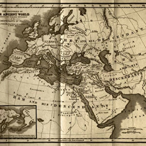
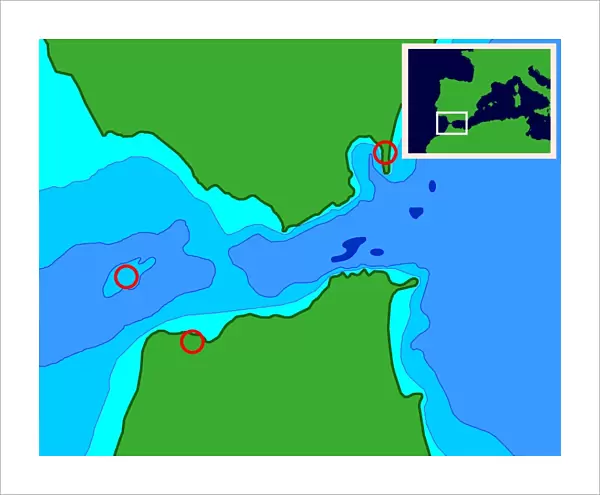
Possible Atlantis. Computer-generated map of a proposed location of the mythical city of Atlantis on Spartel Island in the Strait of Gibraltar. The Strait connects the Atlantic Ocean (left) to the Mediterranean Sea (right), and separates Spain in Europe (top) from Morocco in Africa (bottom). The red circles mark Gibraltar (upper right), Tangier (lower left), and Spartel Island (centre left). The island is now about 100 metres below sea level, but during the last ice age it would have been above sea level and may have been inhabited. Rising sea levels at the end of the ice age may have destroyed the island civilisation, leading to the myth of Atlantis sinking beneath the waves
Science Photo Library features Science and Medical images including photos and illustrations
Media ID 6342275
© SEYMOUR/SCIENCE PHOTO LIBRARY
African Ancient Atlantic Atlantis Civilisation Earth Science Graphic Legend Legendary Location Lost City Mediterranean Sea Moroccan Morocco Myth Mythical Mythology North Africa Pre History Prehistorical Spain Spanish Computer Artwork Pillars Of Hercules Strait Of Gibraltar Tangier
20"x16" (+3" Border) Fine Art Print
Discover the enigma of the lost city of Atlantis with our captivating Fine Art Print from Science Photo Library. This mesmerizing computer-generated map depicts a proposed location of Atlantis on Spartel Island in the Strait of Gibraltar, igniting the imagination and fueling the intrigue surrounding this legendary city. Bring the mystery of Atlantis into your home or office with this stunning, high-quality fine art print from Media Storehouse. Perfect for those who seek to explore the unknown and add a touch of wonder to their surroundings.
20x16 image printed on 26x22 Fine Art Rag Paper with 3" (76mm) white border. Our Fine Art Prints are printed on 300gsm 100% acid free, PH neutral paper with archival properties. This printing method is used by museums and art collections to exhibit photographs and art reproductions.
Our fine art prints are high-quality prints made using a paper called Photo Rag. This 100% cotton rag fibre paper is known for its exceptional image sharpness, rich colors, and high level of detail, making it a popular choice for professional photographers and artists. Photo rag paper is our clear recommendation for a fine art paper print. If you can afford to spend more on a higher quality paper, then Photo Rag is our clear recommendation for a fine art paper print.
Estimated Image Size (if not cropped) is 50.8cm x 40.6cm (20" x 16")
Estimated Product Size is 66cm x 55.9cm (26" x 22")
These are individually made so all sizes are approximate
Artwork printed orientated as per the preview above, with landscape (horizontal) orientation to match the source image.
FEATURES IN THESE COLLECTIONS
> Africa
> Morocco
> Related Images
> Africa
> Related Images
> Arts
> Artists
> O
> Oceanic Oceanic
> Europe
> Related Images
> Europe
> Spain
> Related Images
EDITORS COMMENTS
This print showcases a computer-generated map proposing the possible location of the legendary city of Atlantis on Spartel Island, nestled in the Strait of Gibraltar. The image beautifully illustrates how this strait connects the vast Atlantic Ocean to the enchanting Mediterranean Sea, while separating Spain and Morocco. Marked by vibrant red circles are notable landmarks such as Gibraltar, Tangier, and Spartel Island itself. Although currently submerged approximately 100 meters below sea level, during the last ice age, this island would have stood proudly above water and potentially harbored an ancient civilization. However, as sea levels rose at the end of this glacial period, it is believed that this island civilization may have met its tragic demise - leading to the enduring myth of Atlantis sinking beneath oceanic depths. With elements encompassing European history and legend intertwined with African mythology and geology, this thought-provoking illustration delves into our fascination with lost cities and prehistoric civilizations. It serves as a reminder of humanity's enduring curiosity about our past and our relentless pursuit to uncover hidden truths buried within Earth's diverse landscapes. Presented by Science Photo Library without any commercial intent or affiliation with a specific company or brand, this remarkable artwork invites us to ponder upon one of history's greatest enigmas - Atlantis: a mythical realm forever shrouded in mystery yet eternally captivating our imagination.
MADE IN THE USA
Safe Shipping with 30 Day Money Back Guarantee
FREE PERSONALISATION*
We are proud to offer a range of customisation features including Personalised Captions, Color Filters and Picture Zoom Tools
SECURE PAYMENTS
We happily accept a wide range of payment options so you can pay for the things you need in the way that is most convenient for you
* Options may vary by product and licensing agreement. Zoomed Pictures can be adjusted in the Cart.