Home > Europe > Portugal > Maps
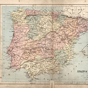
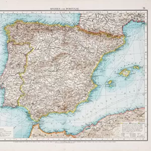
Antique map of Spain and Portugal

![]()
Wall Art and Photo Gifts from Fine Art Storehouse
Antique map of Spain and Portugal
Antique map of Spain and Portugal from 1891 with a detail of Santander
Unleash your creativity and transform your space into a visual masterpiece!
duncan1890
Media ID 15107377
© This content is subject to copyright
1890s Cantabria Colour Colours Equipment Iberian Peninsula Image Created 1890 1899 Navigational Equipment Portugal Portuguese Retro Southern Europe Spanish Styles Supplies Traditional Victorian Obsolete Santander
FEATURES IN THESE COLLECTIONS
> Europe
> Portugal
> Paintings
> Fine Art Storehouse
> Map
> Historical Maps
> Maps and Charts
> Early Maps
> Maps and Charts
> Spain
MADE IN THE USA
Safe Shipping with 30 Day Money Back Guarantee
FREE PERSONALISATION*
We are proud to offer a range of customisation features including Personalised Captions, Color Filters and Picture Zoom Tools
SECURE PAYMENTS
We happily accept a wide range of payment options so you can pay for the things you need in the way that is most convenient for you
* Options may vary by product and licensing agreement. Zoomed Pictures can be adjusted in the Cart.