Home > Arts > Still life artwork > Watercolor paintings > Fine art
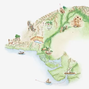
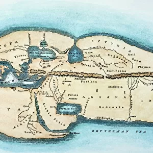
Illustrated map of ancient Sumer with rivers Tigris and Euphrates

![]()
Wall Art and Photo Gifts from Fine Art Storehouse
Illustrated map of ancient Sumer with rivers Tigris and Euphrates
Unleash your creativity and transform your space into a visual masterpiece!
Dorling Kindersley
Media ID 13540951
© This content is subject to copyright
Ancient Civilisations Ancient History Background People Delta Empire Geography Human Settlement Illustrated Map Incidental People Mesopotamia Mesopotamian Middle East Sumer Sumerian Civilization Euphrates River River Euphrates River Tigris Sumerian Tigris River Watercolour Painting
FEATURES IN THESE COLLECTIONS
> Arts
> Landscape paintings
> Waterfall and river artworks
> River artworks
> Arts
> Still life artwork
> Watercolor paintings
> Fine art
> Fine Art Storehouse
> Photo Libraries
> Dorling Kindersley Prints
> Maps and Charts
> Early Maps
EDITORS COMMENTS
This print showcases an exquisitely detailed illustrated map of ancient Sumer, transporting us back to the cradle of civilization. The artist's skillful watercolor painting brings to life the vibrant landscape, with its prominent rivers Tigris and Euphrates gracefully winding through the region. Intriguingly, this depiction not only highlights the physical geography but also offers a glimpse into the rich history and human settlements that once thrived in Mesopotamia. The ancient Sumerian empire emerges before our eyes, revealing bustling cities and intricate delta formations along these vital waterways. The white background serves as a canvas for this mesmerizing artwork, allowing every stroke of color to shine brightly. As we explore this visual treasure trove, we are reminded of how civilizations flourished in this land thousands of years ago. With its horizontal composition and attention to detail, this studio-shot illustration captures both the grandeur and intricacy of ancient Sumerian civilization. It is a testament to humanity's ingenuity and resilience throughout time. Dorling Kindersley has masterfully crafted this piece, immersing us in an era long gone yet forever etched in our collective memory. Whether you are a history enthusiast or simply appreciate fine artistry, this illustrated map transports you on a journey through one of humanity's most significant chapters – Ancient Mesopotamia.
MADE IN THE USA
Safe Shipping with 30 Day Money Back Guarantee
FREE PERSONALISATION*
We are proud to offer a range of customisation features including Personalised Captions, Color Filters and Picture Zoom Tools
SECURE PAYMENTS
We happily accept a wide range of payment options so you can pay for the things you need in the way that is most convenient for you
* Options may vary by product and licensing agreement. Zoomed Pictures can be adjusted in the Cart.