Framed Print > Arts > Pop art > Bold patterns > Retro-inspired pop-art collection
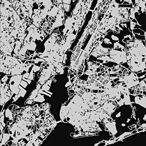
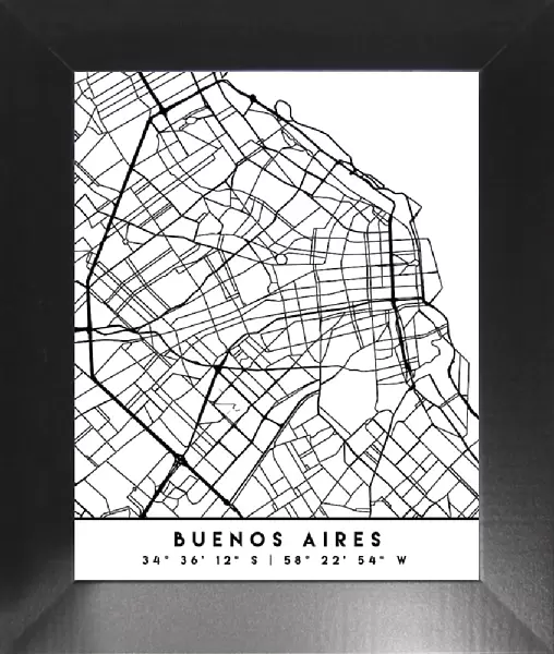
Framed Print : Black Maps 17


![]()
Framed Photos from 1x Innovations
Black Maps 17
Emiliano Deificus
Media ID 35383504
12"x10" Modern Frame
10x8 Print in an MDF Wooden Frame with 180 gsm Satin Finish Paper. Glazed using shatter proof thin plexi glass. Frame thickness is 1 inch and depth 0.75 inch. Fluted cardboard backing held with clips. Supplied ready to hang with sawtooth hanger and rubber bumpers. Spot clean with a damp cloth. Packaged foam wrapped in a card.
Contemporary Framed and Mounted Prints - Professionally Made and Ready to Hang
Estimated Image Size (if not cropped) is 25.4cm x 25.4cm (10" x 10")
Estimated Product Size is 25.4cm x 30.5cm (10" x 12")
These are individually made so all sizes are approximate
Artwork printed orientated as per the preview above, with landscape (horizontal) or portrait (vertical) orientation to match the source image.
FEATURES IN THESE COLLECTIONS
> 1x Gallery
> Maps
> Abstract Art
> Painting
> Related Images
> Arts
> Abstract art
> Arts
> Still life artwork
> Abstract art
> Fine art
> Arts
> Still life artwork
> Abstract art
> Street art
> Arts
> Minimalist artwork
> Abstract art
> Fine art
> Arts
> Modern art pieces
> Abstract art
> Fine art
> Arts
> Pop art
> Bold patterns
> Retro-inspired pop-art collection
> Arts
> Portraits
> Abstract art
> Abstract art gallery
> Arts
> Portraits
> Abstract art
> Abstract paintings
> Arts
> Portraits
> Abstract art
> Fine art gallery
VISUAL DESCRIPTION
This image displays a stylized black and white line drawing of the street map of Buenos Aires, Argentina. The map shows a dense network of streets and avenues characteristic of a large city, with both grid-like patterns in some areas and more irregular layouts in others. Notably absent are any geographical features or landmarks that would offer context beyond the roadways themselves. The bold text "BUENOS AIRES" is prominently displayed at the bottom, along with the city's approximate coordinates: 34° 36' 12" S latitude and 58° 22' 54" W longitude. This type of representation highlights urban planning and can serve as an abstract artistic interpretation or as a simplified navigational tool for understanding the city's layout.
MADE IN THE USA
Safe Shipping with 30 Day Money Back Guarantee
FREE PERSONALISATION*
We are proud to offer a range of customisation features including Personalised Captions, Color Filters and Picture Zoom Tools
SECURE PAYMENTS
We happily accept a wide range of payment options so you can pay for the things you need in the way that is most convenient for you
* Options may vary by product and licensing agreement. Zoomed Pictures can be adjusted in the Cart.