Framed Print > Europe > Spain > Maps
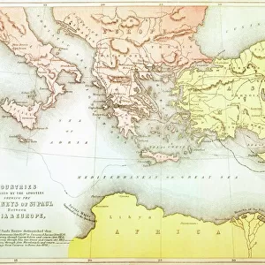
Framed Print : 19Th Century Map Showing Provinces And Cities Of Roman Spain


![]()
Framed Photos from Design Pics
19Th Century Map Showing Provinces And Cities Of Roman Spain
Design Pics offers Distinctively Different Imagery representing over 1,500 contributors
Media ID 18188512
© Ken Welsh / Design Pics
Cartography Cities Drawings Engravings Illustrations Prints Provinces Roman Spain Spanish Nineteenth
12"x10" Modern Frame
Step back in time with our exquisite framed print, "19Th Century Map Showing Provinces and Cities of Roman Spain" by Ken Welsh from Design Pics. This captivating piece transports you back to the ancient Roman world, showcasing intricate detail of the provinces and cities that once thrived under Roman rule. The vintage map design adds a touch of history and sophistication to any space. Each print is meticulously framed with care, ensuring a stunning presentation that is sure to impress.
10x8 Print in an MDF Wooden Frame with 180 gsm Satin Finish Paper. Glazed using shatter proof thin plexi glass. Frame thickness is 1 inch and depth 0.75 inch. Fluted cardboard backing held with clips. Supplied ready to hang with sawtooth hanger and rubber bumpers. Spot clean with a damp cloth. Packaged foam wrapped in a card.
Contemporary Framed and Mounted Prints - Professionally Made and Ready to Hang
Estimated Image Size (if not cropped) is 25.4cm x 25.4cm (10" x 10")
Estimated Product Size is 30.5cm x 25.4cm (12" x 10")
These are individually made so all sizes are approximate
Artwork printed orientated as per the preview above, with landscape (horizontal) or portrait (vertical) orientation to match the source image.
FEATURES IN THESE COLLECTIONS
> Maps and Charts
> Related Images
> Maps and Charts
> Spain
EDITORS COMMENTS
This 19th-century map, skillfully crafted by Ken Welsh, takes us on a journey back in time to the Roman era in Spain. A true masterpiece of cartography, this print showcases the provinces and cities that once thrived under Roman rule. With its horizontal layout, it effortlessly captures the vastness of this ancient empire's influence. As we delve into every intricate detail of this illustration, we are transported to a world where names like Hispania Tarraconensis and Baetica hold great significance. The carefully etched lines depict borders that defined these regions centuries ago, while delicate engravings highlight major cities such as Corduba (modern-day Córdoba) and Emerita Augusta (now Mérida). The artistic finesse with which Ken Welsh has brought this historical map to life is truly commendable. Each stroke tells a story of conquests and cultural exchange that shaped the landscape we know today as Spain. This print serves not only as an educational tool but also as a window into the past for those who appreciate history's rich tapestry. Whether displayed in a classroom or adorning the walls of an avid historian's study, this 19th-century map offers endless possibilities for exploration and discovery. It invites us to marvel at the grandeur of Roman Spain while reminding us how far our world has come since then.
MADE IN THE USA
Safe Shipping with 30 Day Money Back Guarantee
FREE PERSONALISATION*
We are proud to offer a range of customisation features including Personalised Captions, Color Filters and Picture Zoom Tools
SECURE PAYMENTS
We happily accept a wide range of payment options so you can pay for the things you need in the way that is most convenient for you
* Options may vary by product and licensing agreement. Zoomed Pictures can be adjusted in the Cart.