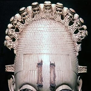
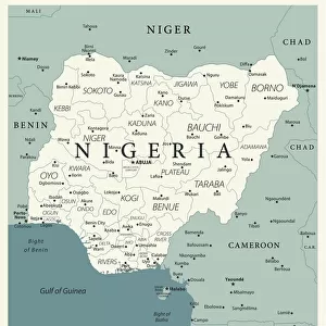
Framed Print > Africa > Benin > Maps
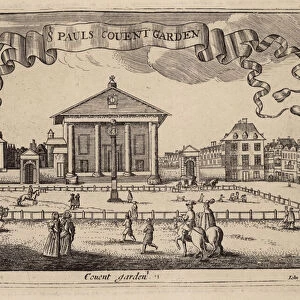
Framed Print : A chart of Guinea describing the sea coast from Cape de Verde to Cape Bona Esperanca, 1677 (coloured engraving)
")

")

![]()
Framed Photos from Fine Art Finder
A chart of Guinea describing the sea coast from Cape de Verde to Cape Bona Esperanca, 1677 (coloured engraving)
7340049 A chart of Guinea describing the sea coast from Cape de Verde to Cape Bona Esperanca, 1677 (coloured engraving) by Seller, John (1632-97); 43x54 cm; National Maritime Museum, London, UK; (add.info.: Creator: John Seller
Scale: [ca. 1:11 000 000 (bar)]. Cartographic Note: North at 90 degrees. Borders graduated for latitude. Plane chart. Bar scales in English and French leagues, Dutch miles and Spanish leagues, In this revision, Africa has been extended south beyond the 35 degree parallel. Changes have been made to the shoreline and place names on the Gold Coast and Benin; Anabona Island has moved east, and more names have been included. Additional Places: Atlantic Africa.); © National Maritime Museum, Greenwich, London
Media ID 38371922
© © National Maritime Museum, Greenwich, London / Bridgeman Images
Atlantic Atlantic Ocean Cape Verde Coast Line Guinea West Africa West African Western Africans
12"x10" Modern Frame
Transport yourself back in time with this beautifully detailed framed print of "A chart of Guinea" from 1677. Perfect for adding a touch of history and sophistication to any room.
10x8 Print in an MDF Wooden Frame with 180 gsm Satin Finish Paper. Glazed using shatter proof thin plexi glass. Frame thickness is 1 inch and depth 0.75 inch. Fluted cardboard backing held with clips. Supplied ready to hang with sawtooth hanger and rubber bumpers. Spot clean with a damp cloth. Packaged foam wrapped in a card.
Contemporary Framed and Mounted Prints - Professionally Made and Ready to Hang
Estimated Image Size (if not cropped) is 25.4cm x 25.4cm (10" x 10")
Estimated Product Size is 30.5cm x 25.4cm (12" x 10")
These are individually made so all sizes are approximate
Artwork printed orientated as per the preview above, with landscape (horizontal) or portrait (vertical) orientation to match the source image.
FEATURES IN THESE COLLECTIONS
> Fine Art Finder
> Artists
> Abraham Ortelius
> Fine Art Finder
> Artists
> John Seller
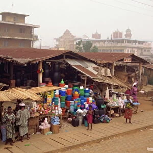
> Africa
> Benin
> Related Images
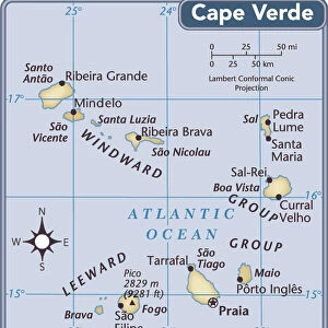
> Africa
> Cape Verde
> Maps
> Africa
> Cape Verde
> Related Images
> Africa
> Guinea
> Related Images
> Africa
> South Africa
> Maps
> Africa
> South Africa
> Related Images
> Arts
> Artists
> B
> Benin Benin
> Arts
> Artists
> O
> Oceanic Oceanic
EDITORS COMMENTS
This stunning coloured engraving from 1677 depicts a chart of Guinea, describing the sea coast from Cape de Verde to Cape Bona Esperanca. Created by John Seller, this intricate map showcases the beauty and detail of cartography in the 17th century.
The scale of the map is approximately 1:11,000,000 with north positioned at 90 degrees. The borders are graduated for latitude and include bar scales in English and French leagues, Dutch miles, and Spanish leagues. Africa has been extended south beyond the 35-degree parallel in this revision, with changes made to the shoreline and place names on the Gold Coast and Benin.
The vibrant colours used in this engraving bring to life the coastal landscape of West Africa, capturing its rich history and maritime significance. From Cape Verde to Cape Bona Esperanca, every detail is meticulously rendered for viewers to explore.
This historical artwork offers a glimpse into early cartography techniques and serves as a valuable piece of African history. The inclusion of additional place names adds depth to our understanding of Atlantic Africa during this time period.
Overall, this print is not just a map but a work of art that celebrates both the beauty and complexity of Guinea's coastline in the 17th century.
MADE IN THE USA
Safe Shipping with 30 Day Money Back Guarantee
FREE PERSONALISATION*
We are proud to offer a range of customisation features including Personalised Captions, Color Filters and Picture Zoom Tools
SECURE PAYMENTS
We happily accept a wide range of payment options so you can pay for the things you need in the way that is most convenient for you
* Options may vary by product and licensing agreement. Zoomed Pictures can be adjusted in the Cart.