Framed Print > Europe > France > Canton > Doubs
Framed Print : Le Doubs (25), Franche Comte (Franche-Comte) - France and its Colonies. Atlas illustrates one hundred and five maps from the maps of the depot of war, bridges and footwear and the Navy by M. VUILLEMIN. 1876
, Franche Comte (Franche-Comte) - France and its Colonies. Atlas illustrates one hundred and five maps from the maps of the depot of war, bridges and footwear and the Navy by M. VUILLEMIN. 1876")
, Franche Comte (Franche-Comte) - France and its Colonies. Atlas illustrates one hundred and five maps from the maps of the depot of war, bridges and footwear and the Navy by M. VUILLEMIN. 1876")

![]()
Framed Photos from Fine Art Finder
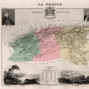
Le Doubs (25), Franche Comte (Franche-Comte) - France and its Colonies. Atlas illustrates one hundred and five maps from the maps of the depot of war, bridges and footwear and the Navy by M. VUILLEMIN. 1876
XEE4144592 Le Doubs (25), Franche Comte (Franche-Comte) - France and its Colonies. Atlas illustrates one hundred and five maps from the maps of the depot of war, bridges and footwear and the Navy by M. VUILLEMIN. 1876. by Vuillemin, Alexandre (1812-1886); Private Collection; (add.info.: Le Doubs (25), Franche Comte (Franche-Comte) - France and its Colonies. Atlas illustrates one hundred and five maps from the maps of the depot of war, bridges and footwear and the Navy by M. VUILLEMIN. 1876.); Stefano Bianchetti; French, out of copyright
Media ID 25153712
© Stefano Bianchetti / Bridgeman Images
Atlas Book Doubs 25 Franche Comt And Xe9 Franche Comte Geographical Map
12"x10" Modern Frame
Step back in time with our exquisite Framed Print of Le Doubs (25), Franche Comte (Franche-Comte) - France and its Colonies Atlas. This stunning piece, featuring one hundred and five maps from the depot of war, bridges and footwear, and the Navy by M. Vuillemin, dates back to 1876. Meticulously reproduced, this framed print showcases intricate details and vibrant colors, transporting you to a bygone era. Add an air of sophistication and historical charm to any room with this unique and captivating addition to your decor. © Stefano Bianchetti, from Fine Art Finder.
10x8 Print in an MDF Wooden Frame with 180 gsm Satin Finish Paper. Glazed using shatter proof thin plexi glass. Frame thickness is 1 inch and depth 0.75 inch. Fluted cardboard backing held with clips. Supplied ready to hang with sawtooth hanger and rubber bumpers. Spot clean with a damp cloth. Packaged foam wrapped in a card.
Contemporary Framed and Mounted Prints - Professionally Made and Ready to Hang
Estimated Image Size (if not cropped) is 25.4cm x 25.4cm (10" x 10")
Estimated Product Size is 30.5cm x 25.4cm (12" x 10")
These are individually made so all sizes are approximate
Artwork printed orientated as per the preview above, with landscape (horizontal) or portrait (vertical) orientation to match the source image.
FEATURES IN THESE COLLECTIONS
> Fine Art Finder
> Artists
> Alexandre Vuillemin
> Europe
> France
> Canton
> Doubs
> Maps and Charts
> Related Images
> Services
> Royal Navy
EDITORS COMMENTS
This print showcases a historical map titled "Le Doubs (25), Franche Comte (Franche-Comte) - France and its Colonies". Created in 1876 by Alexandre Vuillemin, this atlas illustrates an impressive collection of one hundred and five maps sourced from the depot of war, bridges, footwear, and the Navy. The intricate details and vibrant colors bring to life the geographical landscape of France during that era. The map focuses on Le Doubs, a department located in the eastern part of France. Franche Comte is also highlighted as it was historically associated with Le Doubs. This region holds great significance due to its strategic location bordering Switzerland. It offers a glimpse into the past, showcasing not only topographical features but also important landmarks such as bridges. The artist behind this masterpiece is Stefano Bianchetti, who skillfully captured every minute detail through engraving techniques. The use of color adds depth and richness to each element depicted on the map. This print serves as a valuable historical artifact for geography enthusiasts or anyone interested in exploring France's colonial history. Its inclusion in an atlas book further emphasizes its importance as a comprehensive resource for understanding various aspects related to war strategies, infrastructure development like bridges, naval operations, and even footwear manufacturing during that time period. Overall, this image provides an intriguing visual representation of France's territorial expansion and highlights significant regions within the country during the late 19th century.
MADE IN THE USA
Safe Shipping with 30 Day Money Back Guarantee
FREE PERSONALISATION*
We are proud to offer a range of customisation features including Personalised Captions, Color Filters and Picture Zoom Tools
SECURE PAYMENTS
We happily accept a wide range of payment options so you can pay for the things you need in the way that is most convenient for you
* Options may vary by product and licensing agreement. Zoomed Pictures can be adjusted in the Cart.