Framed Print > Fine Art Finder > Maps (celestial & Terrestrial)
Framed Print : The Antilles and the Gulf of Mexico, from Atlas de Toutes les Parties Connues


![]()
Framed Photos from Fine Art Finder
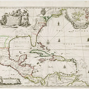
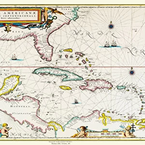
The Antilles and the Gulf of Mexico, from Atlas de Toutes les Parties Connues
KW205836 The Antilles and the Gulf of Mexico, from Atlas de Toutes les Parties Connues du Globe Terrestre by Guillaume Raynal (1713-96) published Geneva, 1780 (coloured engraving) by Bonne, Charles Marie Rigobert (1727-95); Private Collection; Ken Welsh; French, out of copyright
Media ID 12755395
© www.bridgemanimages.com
Bahamas Caribbean Cuba Dominican Republic Florida Haiti Honduras Jamaica Nicaragua
18"x14" Modern Frame
Discover the rich history and beauty of the Antilles and the Gulf of Mexico with our exquisite Framed Print from Media Storehouse. This stunning coloured engraving is taken from the Atlas de Toutes les Parties Connues by Guillaume Raynal and published in Geneva in 1780. Meticulously crafted by Bonne, this rare and captivating piece showcases the intricate detail and artistry of the 18th century. Bring the wonders of the Atlantic World into your home or office and elevate your decor with this unique and authentic work of art.
16x12 Print in an MDF Wooden Frame with 180 gsm Satin Finish Paper. Glazed using shatter proof thin plexiglass. Frame thickness is 1 inch and depth 0.75 inch. Fluted cardboard backing held with clips. Supplied ready to hang with sawtooth hanger and rubber bumpers. Spot clean with a damp cloth. Packaged foam wrapped in a card.
Contemporary Framed and Mounted Prints - Professionally Made and Ready to Hang
Estimated Image Size (if not cropped) is 40.6cm x 35.6cm (16" x 14")
Estimated Product Size is 45.7cm x 35.6cm (18" x 14")
These are individually made so all sizes are approximate
Artwork printed orientated as per the preview above, with landscape (horizontal) orientation to match the source image.
FEATURES IN THESE COLLECTIONS
> Fine Art Finder
> Artists
> Charles Marie Rigobert Bonne
> Fine Art Finder
> Maps (celestial & Terrestrial)
EDITORS COMMENTS
This print, titled "The Antilles and the Gulf of Mexico" takes us on a visual journey through the Caribbean islands and the vast expanse of the Gulf. Created by Guillaume Raynal in 1780, this coloured engraving is part of his renowned Atlas de Toutes les Parties Connues du Globe Terrestre. As we gaze upon this historical map, our eyes are immediately drawn to the intricate details that bring these lands to life. From Cuba's iconic shape to Haiti and the Dominican Republic sharing Hispaniola, each island is meticulously depicted with precision and accuracy. The vibrant colors used in this print add an element of enchantment to its composition. Shades of green represent lush vegetation while various shades of blue beautifully depict surrounding waters. This combination creates a harmonious balance between land and sea. Beyond just aesthetics, this map also serves as a testament to exploration during that era. It showcases not only well-known destinations like Jamaica and the Bahamas but also lesser-known regions such as Honduras and Nicaragua. This particular print captures a moment frozen in time—a snapshot from centuries ago when these territories were still being discovered by explorers seeking new horizons. Now preserved within a private collection, it offers us an opportunity to reflect on our shared history while appreciating both the artistry behind its creation and its significance as a valuable piece of cartographic heritage.
MADE IN THE USA
Safe Shipping with 30 Day Money Back Guarantee
FREE PERSONALISATION*
We are proud to offer a range of customisation features including Personalised Captions, Color Filters and Picture Zoom Tools
SECURE PAYMENTS
We happily accept a wide range of payment options so you can pay for the things you need in the way that is most convenient for you
* Options may vary by product and licensing agreement. Zoomed Pictures can be adjusted in the Cart.