Framed Print > Arts > Artists > B > Charles Marie Rigobert Bonne
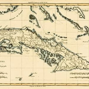
Framed Print : Cuba, from Atlas de Toutes les Parties Connues du Globe Terrestre by Guillaume Raynal


![]()
Framed Photos from Fine Art Finder
Cuba, from Atlas de Toutes les Parties Connues du Globe Terrestre by Guillaume Raynal
KW206600 Cuba, from Atlas de Toutes les Parties Connues du Globe Terrestre by Guillaume Raynal (1713-96) published 1780 (coloured engraving) by Bonne, Charles Marie Rigobert (1727-95); Private Collection; Ken Welsh; French, out of copyright
Media ID 12755731
© www.bridgemanimages.com
Antilles Caribbean Cuban Havana West Indian
18"x14" Modern Frame
Discover the rich history and culture of Cuba with our elegant Framed Prints from Media Storehouse. Featuring the captivating image "Cuba" from Atlas de Toutes les Parties Connues du Globe Terrestre by Guillaume Raynal, published in 1780. This exquisite coloured engraving, originally produced by Bonne, offers a captivating glimpse into the past with its intricate details and vibrant colours. Add a touch of history and sophistication to your home or office with this stunning Framed Print from Media Storehouse.
16x12 Print in an MDF Wooden Frame with 180 gsm Satin Finish Paper. Glazed using shatter proof thin plexiglass. Frame thickness is 1 inch and depth 0.75 inch. Fluted cardboard backing held with clips. Supplied ready to hang with sawtooth hanger and rubber bumpers. Spot clean with a damp cloth. Packaged foam wrapped in a card.
Contemporary Framed and Mounted Prints - Professionally Made and Ready to Hang
Estimated Image Size (if not cropped) is 40.6cm x 35.6cm (16" x 14")
Estimated Product Size is 45.7cm x 35.6cm (18" x 14")
These are individually made so all sizes are approximate
Artwork printed orientated as per the preview above, with landscape (horizontal) orientation to match the source image.
FEATURES IN THESE COLLECTIONS
> Fine Art Finder
> Artists
> Charles Marie Rigobert Bonne
> Arts
> Artists
> B
> Charles Marie Rigobert Bonne
> Maps and Charts
> Related Images
> North America
> Cuba
> Cuba Heritage Sites
> Old Havana and its Fortification System
> North America
> Cuba
> Havana
> North America
> Cuba
> Maps
> North America
> Cuba
> Related Images
EDITORS COMMENTS
This print showcases a historical map of Cuba, taken from the renowned Atlas de Toutes les Parties Connues du Globe Terrestre by Guillaume Raynal. Published in 1780, this coloured engraving provides a fascinating glimpse into the island's past. The intricate details and vibrant colors bring to life the beauty and allure of this Caribbean gem. The map highlights not only Cuba's geographical features but also its significance as part of the West Indies and the Antilles region. From Havana to other coastal towns, every corner of this enchanting island is meticulously depicted, making it an invaluable resource for historians and geography enthusiasts alike. Displayed in a private collection, this particular print captures the essence of Charles Marie Rigobert Bonne's artistic talent. His skillful craftsmanship shines through in every line and curve, creating a visual masterpiece that transports viewers back in time. As we admire this stunning image, let us appreciate both its aesthetic appeal and its historical value. It serves as a reminder of how art can preserve our collective heritage while simultaneously evoking emotions and sparking curiosity about distant lands. Whether you have an affinity for maps or simply appreciate fine art, this print offers an exquisite addition to any collection.
MADE IN THE USA
Safe Shipping with 30 Day Money Back Guarantee
FREE PERSONALISATION*
We are proud to offer a range of customisation features including Personalised Captions, Color Filters and Picture Zoom Tools
SECURE PAYMENTS
We happily accept a wide range of payment options so you can pay for the things you need in the way that is most convenient for you
* Options may vary by product and licensing agreement. Zoomed Pictures can be adjusted in the Cart.