Framed Print > Arts > Artists > H > Hungarian School Hungarian School
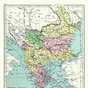
Framed Print : Map of the Kingdom of Hungary and the States which are United to its Crown, pub


![]()
Framed Photos from Fine Art Finder
Map of the Kingdom of Hungary and the States which are United to its Crown, pub
STC101845 Map of the Kingdom of Hungary and the States which are United to its Crown, pub. by Jan Barend Elwe, Amsterdam, 1742 (engraving) by Dutch School, (18th century); Private Collection; The Stapleton Collection; Dutch, out of copyright
Media ID 23366084
© The Stapleton Collection / Bridgeman Images
Balkans Bosnia Bosniaque Bulgaria Croatia Eastern Europe Hungarian Magyar Moldavia Romania Serbia Slovakia Transylvania
12"x10" Modern Frame
Add a touch of historical elegance to your decor with our Framed Print of the Map of the Kingdom of Hungary and the States United to its Crown, published by Bridgeman Images from Fine Art Finder. This exquisite engraving, created in Amsterdam in 1742 by the Dutch School artist Jan Barend Elwe, offers a fascinating glimpse into the rich history of Hungary and its allied states. With intricate detail and beautiful antique aesthetics, this framed print is a must-have for history enthusiasts, world travelers, or anyone seeking to add a touch of timeless charm to their home or office. Bring the past to life with this stunning piece of historical cartography.
10x8 Print in an MDF Wooden Frame with 180 gsm Satin Finish Paper. Glazed using shatter proof thin plexi glass. Frame thickness is 1 inch and depth 0.75 inch. Fluted cardboard backing held with clips. Supplied ready to hang with sawtooth hanger and rubber bumpers. Spot clean with a damp cloth. Packaged foam wrapped in a card.
Contemporary Framed and Mounted Prints - Professionally Made and Ready to Hang
Estimated Image Size (if not cropped) is 25.4cm x 25.4cm (10" x 10")
Estimated Product Size is 30.5cm x 25.4cm (12" x 10")
These are individually made so all sizes are approximate
Artwork printed orientated as per the preview above, with landscape (horizontal) or portrait (vertical) orientation to match the source image.
FEATURES IN THESE COLLECTIONS
> Fine Art Finder
> Artists
> Dutch School
> Fine Art Finder
> Artists
> German School
> Fine Art Finder
> Maps (celestial & Terrestrial)
> Arts
> Artists
> H
> Hungarian School Hungarian School
> Europe
> Bosnia and Herzegovina
> Maps
> Europe
> Bulgaria
> Related Images
> Europe
> Croatia
> Related Images
EDITORS COMMENTS
This engraving, titled "Map of the Kingdom of Hungary and the States which are United to its Crown" takes us on a journey through the rich history and diverse landscapes of Eastern Europe. Created by an anonymous Dutch artist in the 18th century, this intricate map offers a window into a bygone era. The map showcases not only the vast territory of Hungary but also its surrounding states that were united under its crown. From Transylvania to Moldavia, Bosnia to Bulgaria, each region is meticulously depicted with stunning detail. The viewer can trace their finger along the borders and immerse themselves in the complex tapestry of cultures that once thrived within these lands. As we explore this historical gem, it becomes evident that this map serves as more than just a geographical representation; it is a testament to centuries-old empires and kingdoms that have shaped Eastern Europe's identity. It reminds us of forgotten dynasties and long-lost traditions. With every line etched onto paper, we are transported back in time – witnessing battles fought for power, trade routes established for commerce, and alliances forged for survival. This engraving encapsulates both the beauty and complexity inherent in European history. Whether you are an avid historian or simply appreciate fine artistry, this print from Jan Barend Elwe's collection is sure to captivate your imagination. Let it transport you across borders and through time as you unravel the stories hidden within each stroke of ink on paper.
MADE IN THE USA
Safe Shipping with 30 Day Money Back Guarantee
FREE PERSONALISATION*
We are proud to offer a range of customisation features including Personalised Captions, Color Filters and Picture Zoom Tools
SECURE PAYMENTS
We happily accept a wide range of payment options so you can pay for the things you need in the way that is most convenient for you
* Options may vary by product and licensing agreement. Zoomed Pictures can be adjusted in the Cart.