Framed Print > Arts > Artists > M > Gerardus Mercator
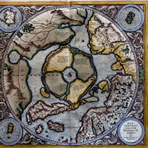
Framed Print : Antique map of Poland - today Lithuania (engraving, 1596)
")
")

![]()
Framed Photos from Fine Art Finder
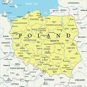
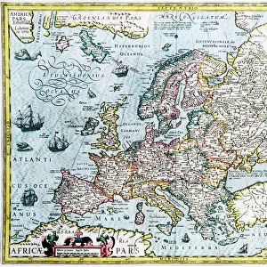
Antique map of Poland - today Lithuania (engraving, 1596)
LRI4716948 Antique map of Poland - today Lithuania (engraving, 1596) by Mercator, Gerardus (1512-94); Private Collection; (add.info.: Prussia, 1630: Antique map of Poland - today Lithuania (Lithuania) - in " Atlas Ssive Corsmographicae Meditationes" by Gerard Mercator (Gerard de Kremer - Gerhard Kremer - Gerardus Mercator) (1512-1594), Duisburg 1596); Luisa Ricciarini; Flemish, out of copyright
Media ID 22836444
© Luisa Ricciarini / Bridgeman Images
Atlas Book Baltic Countries Poland Polish Geographical Map Prussia Prussian
12"x10" Modern Frame
Step back in time with our exquisite Framed Print of an Antique Map of Poland, as it appeared in 1596. This captivating piece, from the renowned collection of Fine Art Finder and created by the master cartographer Gerardus Mercator, showcases intricate details of the region that is now known as Lithuania. The antique engraving, beautifully preserved, is framed to perfection, making it a stunning addition to any room in your home or office. Transport yourself to a bygone era with this unique and intriguing piece of history.
10x8 Print in an MDF Wooden Frame with 180 gsm Satin Finish Paper. Glazed using shatter proof thin plexi glass. Frame thickness is 1 inch and depth 0.75 inch. Fluted cardboard backing held with clips. Supplied ready to hang with sawtooth hanger and rubber bumpers. Spot clean with a damp cloth. Packaged foam wrapped in a card.
Contemporary Framed and Mounted Prints - Professionally Made and Ready to Hang
Estimated Image Size (if not cropped) is 25.4cm x 25.4cm (10" x 10")
Estimated Product Size is 30.5cm x 25.4cm (12" x 10")
These are individually made so all sizes are approximate
Artwork printed orientated as per the preview above, with landscape (horizontal) or portrait (vertical) orientation to match the source image.
FEATURES IN THESE COLLECTIONS
> Fine Art Finder
> Artists
> Gerardus Mercator
> Fine Art Finder
> Artists
> Jan van der (1523-1605) Straet
> Arts
> Artists
> M
> Gerardus Mercator
> Europe
> Lithuania
> Posters
> Europe
> Lithuania
> Related Images
> Europe
> Poland
> Related Images
> Maps and Charts
> Gerardus Mercator's Cartographic
> Maps and Charts
> Related Images
EDITORS COMMENTS
This print showcases an exquisite antique map of Poland, which is known as Lithuania today. Created in 1596 by the renowned cartographer Gerardus Mercator, this engraving is a true masterpiece of historical significance. The map belongs to a private collection and offers a glimpse into the geographical landscape of the region during that era. The intricate details on this map are truly remarkable. It depicts not only Poland (Lithuania) but also Prussia, providing valuable insights into the political boundaries of the time. This particular version was published in Duisburg in 1596 as part of Mercator's famous work "Atlas Ssive Corsmographicae Meditationes". The Flemish artist Luisa Ricciarini has beautifully captured this piece, ensuring its preservation for generations to come. As we explore this antique map, we can't help but marvel at how it transports us back to a different time and place. It serves as a testament to the rich history and cultural heritage of these Baltic countries. Whether you have an interest in geography or simply appreciate fine art, this print is sure to captivate your imagination.
MADE IN THE USA
Safe Shipping with 30 Day Money Back Guarantee
FREE PERSONALISATION*
We are proud to offer a range of customisation features including Personalised Captions, Color Filters and Picture Zoom Tools
SECURE PAYMENTS
We happily accept a wide range of payment options so you can pay for the things you need in the way that is most convenient for you
* Options may vary by product and licensing agreement. Zoomed Pictures can be adjusted in the Cart.