Framed Print > Europe > United Kingdom > England > London > Museums > National Maritime Museum
Framed Print : Map of Hispaniola, 1653 (manuscript)
")
")

![]()
Framed Photos from Fine Art Finder
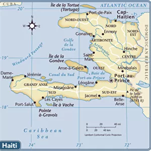
Map of Hispaniola, 1653 (manuscript)
7340470 Map of Hispaniola, 1653 (manuscript) by Comberford, Nicholas (d.1673); 47x45 cm; National Maritime Museum, London, UK; (add.info.: Creator: Nicholas Comberford); © National Maritime Museum, Greenwich, London
Media ID 38410208
© © National Maritime Museum, Greenwich, London / Bridgeman Images
Central America Coast Line Haiti Haitian Islands Isles Santo Domingo Shorelines West Indies 17th Centuries Etats Unis Etats Unis Usa United States Geographer Seawater
18"x14" Modern Frame
Transport yourself back in time with this stunning framed print of the "Map of Hispaniola, 1653" by Nicholas Comberford. A true piece of history for your home decor collection.
16x12 Print in an MDF Wooden Frame with 180 gsm Satin Finish Paper. Glazed using shatter proof thin plexiglass. Frame thickness is 1 inch and depth 0.75 inch. Fluted cardboard backing held with clips. Supplied ready to hang with sawtooth hanger and rubber bumpers. Spot clean with a damp cloth. Packaged foam wrapped in a card.
Contemporary Framed and Mounted Prints - Professionally Made and Ready to Hang
Estimated Image Size (if not cropped) is 40.6cm x 35.6cm (16" x 14")
Estimated Product Size is 45.7cm x 35.6cm (18" x 14")
These are individually made so all sizes are approximate
Artwork printed orientated as per the preview above, with landscape (horizontal) orientation to match the source image.
FEATURES IN THESE COLLECTIONS
> Fine Art Finder
> Artists
> Nicholas Comberford
> Fine Art Finder
> Artists
> Pieter Goos
> Europe
> United Kingdom
> England
> London
> Boroughs
> Greenwich
> Europe
> United Kingdom
> England
> London
> Museums
> Greenwich Heritage Centre
> Europe
> United Kingdom
> England
> London
> Museums
> National Maritime Museum
> Europe
> United Kingdom
> England
> London
> Towns
> Greenwich
> Europe
> United Kingdom
> Heritage Sites
> Maritime Greenwich
> Europe
> United Kingdom
> Maps
> Maps and Charts
> Early Maps
> Maps and Charts
> Related Images
> North America
> Haiti
> Maps
EDITORS COMMENTS
This stunning print of the Map of Hispaniola, dating back to 1653 and created by Nicholas Comberford, offers a fascinating glimpse into the cartography of the 17th century. The intricate details and vibrant colors bring this historical map to life, showcasing the beauty and complexity of early American geography.
As we study this map, we are transported back in time to a period when exploration and discovery were at the forefront of human endeavor. The careful craftsmanship and attention to detail displayed in this manuscript reflect the dedication and skill of its creator, Nicholas Comberford.
Hispaniola, known for its rich history and diverse culture, is depicted with precision on this map. From its coastlines to its interior regions, every aspect of the island is meticulously illustrated for viewers to explore.
Through this artwork, we gain a deeper understanding of not only the geographical layout of Hispaniola but also the artistic techniques used in cartography during that era. It serves as a reminder of our connection to the past and our ongoing fascination with maps as both practical tools and works of art.
This print from Bridgeman Images allows us to appreciate the beauty and significance of historical maps like never before.
MADE IN THE USA
Safe Shipping with 30 Day Money Back Guarantee
FREE PERSONALISATION*
We are proud to offer a range of customisation features including Personalised Captions, Color Filters and Picture Zoom Tools
SECURE PAYMENTS
We happily accept a wide range of payment options so you can pay for the things you need in the way that is most convenient for you
* Options may vary by product and licensing agreement. Zoomed Pictures can be adjusted in the Cart.