Framed Print > Historic > World War I and II > World War I
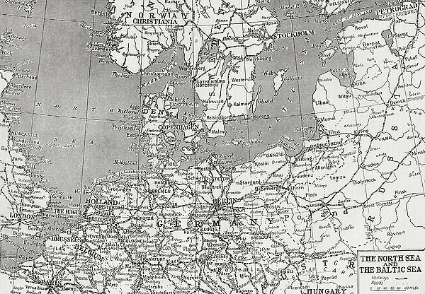
Framed Print : Map showing the North sea and the Baltic sea at the time of the first world war (litho)
![]()

Framed Photos from Fine Art Finder
Map showing the North sea and the Baltic sea at the time of the first world war (litho)
3252859 Map showing the North sea and the Baltic sea at the time of the first world war (litho); Private Collection; (add.info.: Map showing the North sea and the Baltic sea at the time of the first world war. From The War Illustrated Album Deluxe, published 1915.); Photo © Hilary Morgan
Media ID 38151042
© © Hilary Morgan / Bridgeman Images
18"x14" Modern Frame
Bring history into your home with this framed print of a map showing the North Sea and Baltic Sea during World War I. A stunning lithograph from Fine Art Finder, this piece is sure to add a touch of sophistication to any room.
16x12 Print in an MDF Wooden Frame with 180 gsm Satin Finish Paper. Glazed using shatter proof thin plexiglass. Frame thickness is 1 inch and depth 0.75 inch. Fluted cardboard backing held with clips. Supplied ready to hang with sawtooth hanger and rubber bumpers. Spot clean with a damp cloth. Packaged foam wrapped in a card.
Contemporary Framed and Mounted Prints - Professionally Made and Ready to Hang
Estimated Image Size (if not cropped) is 40.6cm x 35.6cm (16" x 14")
Estimated Product Size is 45.7cm x 35.6cm (18" x 14")
These are individually made so all sizes are approximate
Artwork printed orientated as per the preview above, with landscape (horizontal) orientation to match the source image.
FEATURES IN THESE COLLECTIONS
> Fine Art Finder
> Artists
> Theodor de Bry
> Historic
> World War I and II
> World War I
> Maps and Charts
> Related Images
> Maps and Charts
> World
EDITORS COMMENTS
This lithograph print showcases a detailed map of the North Sea and Baltic Sea during the tumultuous time of the First World War. Published in 1915 as part of The War Illustrated Album Deluxe, this historical artifact provides a glimpse into the strategic importance of these bodies of water during one of the most devastating conflicts in human history.
As you study this intricate map, you can almost feel the tension and uncertainty that must have permeated the region during those dark days. The lines and boundaries on the map represent not just geographical features, but also political divisions and military strategies that shaped the course of war.
The North Sea and Baltic Sea were crucial theaters of operation during World War I, with naval battles, blockades, and troop movements all taking place against this maritime backdrop. Countries bordering these seas were deeply impacted by the conflict, their fates intertwined with each other in ways both tragic and profound.
This lithograph is not just a piece of art; it is a window into a pivotal moment in history when nations clashed on land, sea, and air. It serves as a reminder of the sacrifices made by countless individuals during those turbulent years – sacrifices that should never be forgotten or taken for granted.
MADE IN THE USA
Safe Shipping with 30 Day Money Back Guarantee
FREE PERSONALISATION*
We are proud to offer a range of customisation features including Personalised Captions, Color Filters and Picture Zoom Tools
SECURE PAYMENTS
We happily accept a wide range of payment options so you can pay for the things you need in the way that is most convenient for you
* Options may vary by product and licensing agreement. Zoomed Pictures can be adjusted in the Cart.


