Framed Print > Europe > France > Maps
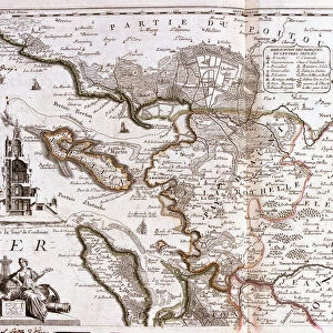
Framed Print : Description of the Normandy pais. Map of the Normandy region in 1620


![]()
Framed Photos from Fine Art Finder
Description of the Normandy pais. Map of the Normandy region in 1620
XEE4405463 Description of the Normandy pais. Map of the Normandy region in 1620. by Unknown Artist, (17th century); Private Collection; (add.info.: Description of the Normandy pais. Map of the Normandy region in 1620.); Stefano Bianchetti; out of copyright
Media ID 22482064
© Stefano Bianchetti / Bridgeman Images
12"x10" Modern Frame
Discover the rich history of Normandy with our exquisite Framed Prints from Media Storehouse. This beautiful map, dated back to 1620, was created by the renowned artist Stefano Bianchetti. The intricate details of the Normandy region are brought to life in this stunning work of art, transporting you back in time. Add a touch of history and sophistication to your home or office with this unique and captivating piece. Each print is carefully framed to preserve its beauty and authenticity, making it a perfect addition to any space. Order now and let the story of Normandy unfold before your eyes.
10x8 Print in an MDF Wooden Frame with 180 gsm Satin Finish Paper. Glazed using shatter proof thin plexi glass. Frame thickness is 1 inch and depth 0.75 inch. Fluted cardboard backing held with clips. Supplied ready to hang with sawtooth hanger and rubber bumpers. Spot clean with a damp cloth. Packaged foam wrapped in a card.
Contemporary Framed and Mounted Prints - Professionally Made and Ready to Hang
Estimated Image Size (if not cropped) is 25.4cm x 25.4cm (10" x 10")
Estimated Product Size is 30.5cm x 25.4cm (12" x 10")
These are individually made so all sizes are approximate
Artwork printed orientated as per the preview above, with landscape (horizontal) or portrait (vertical) orientation to match the source image.
FEATURES IN THESE COLLECTIONS
> Fine Art Finder
> Artists
> Unknown Artist
> Maps and Charts
> Related Images
EDITORS COMMENTS
This print showcases a historical gem - the "Description of the Normandy pais. Map of the Normandy region in 1620". Created by an unknown artist in the 17th century, this map offers a fascinating glimpse into the geography and knowledge of that time. The intricate details and precision of this map are truly remarkable. It provides a comprehensive overview of Normandy, a picturesque region located in northern France. From its rolling hills to its charming coastal towns, every aspect is meticulously depicted, allowing viewers to immerse themselves in the beauty and diversity of this French province. As we gaze upon this print, we can't help but appreciate Stefano Bianchetti's skillful capture that brings out every nuance and fine line from centuries ago. The colors have been preserved flawlessly, making it feel as if we are transported back to 1620 when this map was first created. For history enthusiasts or those with an interest in French geography, this print is an invaluable addition to any collection. Its timeless appeal transcends generations and serves as a reminder of our ever-evolving world. Displayed proudly within private collections around the globe, this piece continues to inspire awe and curiosity about both past eras and present-day landscapes. Let us cherish these glimpses into history through artistry like A© Stefano Bianchetti's incredible photograph capturing such significant cultural artifacts for all to enjoy.
MADE IN THE USA
Safe Shipping with 30 Day Money Back Guarantee
FREE PERSONALISATION*
We are proud to offer a range of customisation features including Personalised Captions, Color Filters and Picture Zoom Tools
SECURE PAYMENTS
We happily accept a wide range of payment options so you can pay for the things you need in the way that is most convenient for you
* Options may vary by product and licensing agreement. Zoomed Pictures can be adjusted in the Cart.