Framed Print > North America > United States of America > New York > New York > Maps
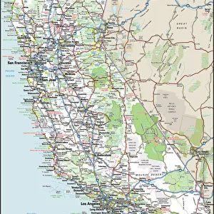
Framed Print : Old map of California 1855


![]()
Framed Photos from Fine Art Storehouse
Old map of California 1855
System of Geography for the use of schools by Sidney E. Morse - Published by Harper & Brothers - New York 1855
Unleash your creativity and transform your space into a visual masterpiece!
THEPALMER
Media ID 13668801
© Roberto A Sanchez
California Cartographer North America San Francisco California Topography Obsolete Retro Styled San Francisco County
12"x10" Modern Frame
Discover the rich history of California with our Old Map of California 1855 by THEPALMER from the Media Storehouse Framed Prints collection. This exquisite piece, taken from the System of Geography for the use of schools by Sidney E. Morse, published by Harper & Brothers in New York, 1855, is a captivating representation of the geography of California during a pivotal time in its history. The intricate details of this antique map are sure to make a stunning addition to any home or office, transporting you back in time. Bring a piece of history into your space with our Old Map of California 1855 Framed Print.
10x8 Print in an MDF Wooden Frame with 180 gsm Satin Finish Paper. Glazed using shatter proof thin plexi glass. Frame thickness is 1 inch and depth 0.75 inch. Fluted cardboard backing held with clips. Supplied ready to hang with sawtooth hanger and rubber bumpers. Spot clean with a damp cloth. Packaged foam wrapped in a card.
Contemporary Framed and Mounted Prints - Professionally Made and Ready to Hang
Estimated Image Size (if not cropped) is 25.4cm x 25.4cm (10" x 10")
Estimated Product Size is 25.4cm x 30.5cm (10" x 12")
These are individually made so all sizes are approximate
Artwork printed orientated as per the preview above, with landscape (horizontal) or portrait (vertical) orientation to match the source image.
FEATURES IN THESE COLLECTIONS
> Fine Art Storehouse
> The Magical World of Illustration
> Palmer Illustrated Collection
> Fine Art Storehouse
> Map
> Historical Maps
> Fine Art Storehouse
> Map
> USA Maps
> Animals
> Mammals
> Cricetidae
> California Mouse
> Maps and Charts
> Related Images
> North America
> Related Images
> North America
> United States of America
> California
> Related Images
> North America
> United States of America
> California
> San Francisco
> North America
> United States of America
> Maps
> North America
> United States of America
> New York
> New York
> Maps
> North America
> United States of America
> New York
> Related Images
EDITORS COMMENTS
This print showcases an exquisite piece of history, an old map of California from the year 1855. A true testament to the artistry and precision of cartography in a bygone era, this retro-styled antique map takes us on a journey back in time. Published by Harper & Brothers in New York, under the guidance of Sidney E. Morse, it was originally intended for educational use in schools. The intricate details and topographical accuracy displayed on this map are truly remarkable. It offers a glimpse into the past, revealing obsolete county lines and physical geography that has evolved over time. The focus on San Francisco County is particularly intriguing as it highlights one of California's most iconic cities during its early development. As we explore every inch of this vertical illustration, we can't help but marvel at how much North America has transformed since then. This vintage gem serves as a reminder of our ever-changing world while also celebrating the rich heritage embedded within these ancient maps. THEPALMER's expertly captured photograph allows us to appreciate not only the historical significance but also the artistic beauty inherent in such artifacts. Whether you're a lover of cartography or simply fascinated by California's past, this print is sure to transport you back to an era long gone – where exploration and discovery were at their peak.
MADE IN THE USA
Safe Shipping with 30 Day Money Back Guarantee
FREE PERSONALISATION*
We are proud to offer a range of customisation features including Personalised Captions, Color Filters and Picture Zoom Tools
SECURE PAYMENTS
We happily accept a wide range of payment options so you can pay for the things you need in the way that is most convenient for you
* Options may vary by product and licensing agreement. Zoomed Pictures can be adjusted in the Cart.