Framed Print > South America > Ecuador > Maps
Framed Print : Antique Map of the Andes Mountains in Ecuador, Venezuela and Columbia - 19th Century


![]()
Framed Photos from Fine Art Storehouse
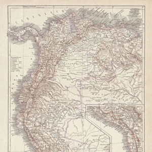
Antique Map of the Andes Mountains in Ecuador, Venezuela and Columbia - 19th Century
Vintage Map of the Andes Mountains in Ecuador, Venezuela and Columbia. Vintage etching circa late 19th century
Unleash your creativity and transform your space into a visual masterpiece!
powerofforever
Media ID 31661187
12"x10" Modern Frame
Step back in time with our Antique Map of the Andes Mountains print from the Media Storehouse Fine Art collection. This stunning vintage piece, titled "Vintage Map of the Andes Mountains in Ecuador, Venezuela and Columbia - 19th Century," showcases the intricate detail of an etching from the late 19th century. The map, created by powerofforever, offers a captivating glimpse into the historical geography of the region, making it a perfect addition to any home or office. Bring the rich history of the Andes Mountains into your space with this beautiful, framed antique map.
10x8 Print in an MDF Wooden Frame with 180 gsm Satin Finish Paper. Glazed using shatter proof thin plexi glass. Frame thickness is 1 inch and depth 0.75 inch. Fluted cardboard backing held with clips. Supplied ready to hang with sawtooth hanger and rubber bumpers. Spot clean with a damp cloth. Packaged foam wrapped in a card.
Contemporary Framed and Mounted Prints - Professionally Made and Ready to Hang
Estimated Image Size (if not cropped) is 25.4cm x 25.4cm (10" x 10")
Estimated Product Size is 30.5cm x 25.4cm (12" x 10")
These are individually made so all sizes are approximate
Artwork printed orientated as per the preview above, with landscape (horizontal) or portrait (vertical) orientation to match the source image.
FEATURES IN THESE COLLECTIONS
> Fine Art Storehouse
> Map
> Historical Maps
> Maps and Charts
> Related Images
> South America
> Ecuador
> Maps
> South America
> Ecuador
> Related Images
> South America
> Venezuela
> Maps
> South America
> Venezuela
> Related Images
EDITORS COMMENTS
This print showcases an exquisite antique map of the majestic Andes Mountains, specifically focusing on the regions of Ecuador, Venezuela, and Colombia. Dating back to the late 19th century, this vintage etching is a true testament to the artistry and precision of cartography during that era. The intricate details and delicate lines beautifully depict the rugged terrain, meandering rivers, and sprawling valleys that define this iconic mountain range. As we gaze upon this historical masterpiece captured by powerofforever for Fine Art Storehouse, we are transported back in time to an era when exploration was at its peak. This map not only serves as a geographical reference but also evokes a sense of wonderment about these awe-inspiring mountains and their significance in shaping the cultural heritage of these South American nations. The faded hues lend an air of nostalgia to the print while adding depth to every contour and elevation line meticulously engraved onto its surface. It is truly remarkable how such a simple piece of paper can encapsulate centuries worth of history and inspire us with its timeless beauty. Whether you have a penchant for geography or simply appreciate fine art, this Antique Map of the Andes Mountains will undoubtedly make a striking addition to any space. Its rich historical value combined with its aesthetic appeal makes it both educational and visually captivating – an ideal conversation starter for admirers from all walks of life.
MADE IN THE USA
Safe Shipping with 30 Day Money Back Guarantee
FREE PERSONALISATION*
We are proud to offer a range of customisation features including Personalised Captions, Color Filters and Picture Zoom Tools
SECURE PAYMENTS
We happily accept a wide range of payment options so you can pay for the things you need in the way that is most convenient for you
* Options may vary by product and licensing agreement. Zoomed Pictures can be adjusted in the Cart.